")
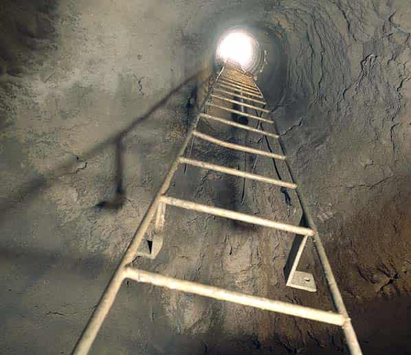
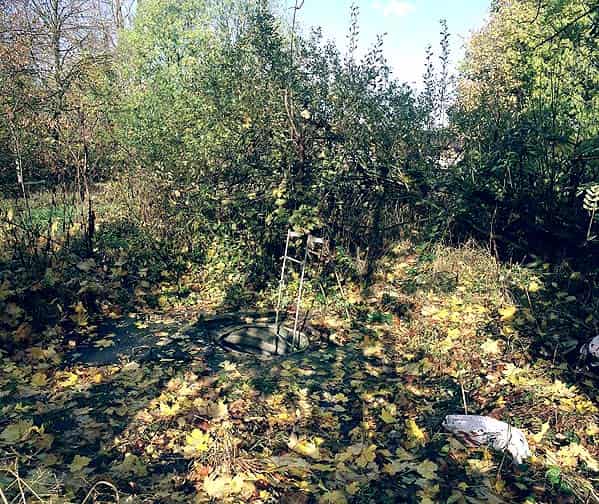
This is a report (with supplementary information) on a Subterranea Britannica ‘fringe’ event, organised and attended by individual members and led by Graham Old, of the local caving club, to whom we are most grateful. Access, arranged via the caving club, is via a 50 ft fixed steel ladder in a narrow vertical shaft below a locked iron cover.
GEOLOGY AND MINING IN AND AROUND READING
The whole of Reading and its immediate area is underlain at a shallow depth by the Upper Cretaceous Upper Chalk, usually covered by the sandy clays of the Lower Tertiary Reading Beds and, frequently, also by the Thames floodplain and terrace gravels. All these geological deposits have been exploited more or less intensively in opencast pits and, in the case of the chalk, also by mining. It has been suggested (Peake, 1913, and Shepherd, 1980) that there were prehistoric flint mines in the chalk at Peppard Common, about five kilometres to the northwest of Emmer Green, but a recent review of English Neolithic flint-mining (Barber, et al., 1999) has discounted this claimed mining site as unproven and in their view unlikely.
The Reading district, renowned for its brickmaking industries, has in common with extensive parts of north Kent, south-east London, and other areas such as the Sudbury district in Suffolk, numerous chalk mines worked below, and in conjunction with, brickfields. A percentage of chalk was added to the brick clays before firing, to counteract shrinkage. Whitaker, et al. (1872) noted that ‘In brickmaking chalk is often used, being ground up and run into the other materials in a liquid state,’ presumably meaning a chalk-water slurry, which would imply a need for a reasonable water supply and thus (before mains water was laid on) a substantially yielding well. Such a well, passing through 61 feet of Reading Beds into the Chalk, is noted by Blake (1903.)
Apart from Emmer Green, chalk mines (often if not always below brickfields) are known at various places in and around Reading (Carter, 1979.) The partial collapse of those at Field Road, Coley (SU 711728) in western Reading, caused extensive damage in the first two years of the 21st century, followed a year later by further ground collapses in Palmer Park (SU 737732) on the east side of the town. Further into Berkshire, chalk mines in the Newbury district, especially at Yattendon, have been investigated in recent years.
The chalk below the Emmer Green outlier is described in modern terms (Mathers and Smith, 2000) as ‘white soft and nodular chalk with abundant flint seams’ of the Seaford Chalk Member. The same authors refer to the overlying Woolwich and Reading Beds, the Lambeth Group in modern terminology, with the Upnor Formation at its base. The Upnor Formation is a condensed marine sequence, usually less than 1 metre thick, containing highly glauconitic, green, blue, and grey sands and clays, containing fossil fish, oysters, etc .. with large irregularly shaped glauconite-coated flint nodules and rounded flint pebbles [the Bullhead Bed] The old Chalk sea bed is irregularly and extensively bored. The overlying clays are generally of the order of 20m thick.
EMMER GREEN AND ITS AREA
Reading, from its commencement as a town on the river Kennet, has expanded over the years and now has within its boundaries parts of former Berkshire, south of the Thames, and Oxfordshire, north of the river. Former brickfields worked at what were once the edges of the built up area (and the chalk mines below them) have thus been built over as Reading expanded. This expansion of the built up area reached the Rose Hill brickfields site in Emmer Green in the late 1970s. Emmer Green (spelt Emmir Green in earlier sources) is some five kilometres north-east of the Caversham Bridge, and reached via the Peppard Road (B 481). From Caversham, this road ascends the hill beside Caversham Park, crossing a prominent river terrace half way up, and levelling out at Emmer Green, where there will be found a pond, two public houses, and a few shops at the heart of what is now a suburb of Reading.
The hamlet was too small to be noticed in The Parliamentary Gazetter of 1840 - 41 (1842) and fell within Caversham parish. The entire parish of Caversham had 1,069 inhabitants in 1801, and this had grown to only 1,369 (occupying 260 houses) by 1831. Most of these people lived in Caversham itself, beside the Thames. Caversham, including Emmer Green, was transferred from Oxfordshire to Reading in 1911.
THE LOCAL DEMAND FOR MINERALS
Heavy soils on the clay outcrops, and acid soils on the gravels, probably called for the use of either raw chalk or of lime to lighten or neutralise them for agricultural uses. Both chalk and flint might well have been in demand for road-making, or simply for rendering rutted farm trackways between clay fields passable.
Clay for bricks and lime for mortar would have been in demand locally in the last four centuries or so, and chalk blocks and flint nodules are known to have been used as building materials at Emmer Green. Flints were probably also used on the roads.
Before the middle of the 19th century there was nothing but a few scattered houses, the settlement being no more than a hamlet on the edge of Caversham Park, where a large house had been built in the 1590s, and rebuilt in 1723. Several other large houses followed. A brick kiln appears first (Ormonde, 2003) in what records survive in 1645 (or 1654.) Apart from Caversham Park and local cottages, the greatest demand for bricks locally would have been for the erection of Old Grove House, St. Agnes (about 1650), Tudor Cottage (Surley Row (1540) and the White Horse public house in the 16th century. By the end of the eighteenth century, apart from the rebuilding of Caversham Park, bricks had been required for building Blenheim House (1770), Brickwall House, Caversham Grove (by 1761), Rosehill House (1791), and Springfield St. Luke. Brickwall House (early 18th century) stood beside the brickfields in the V between Kiln Road and Peppard Road, and is reported to have been erected for the brickyard foreman. It is now demolished, but there is a length of old brick wall built in rat-trap bond along part of the Kiln Road frontage which appears to be part of the old brickworks. The 19th century saw a rising demand for bricks, with the erection of the Black Horse public house (by 1830), Caversham Hill Chapel (1827), the Emmer Green Parochial School (1877), Grovehill House, and Hill House. Caversham Hill Chapel (1827) is brick, but with a Bath stone tower (the Kennet and Avon Canal, opened through to the Thames in 1810, allowed Bath stone to be brought into the district at a reasonable cost.) The first Anglican church (St. Barnabas (1898) at Emmer Green was an ‘iron church’ (now the church hall), the new brick church here dating only from 1925.
Interestingly, the older parts of St. Agnes (1650) are of brick and flint, with chalk block wall linings. A number of other local buildings include flint in their structures, such as the 17th century brick and flint house now number 46 Surley Row.
It is probably safe to assume that all of the older brick buildings of Emmer Green used bricks from the local brickfield, and that the mortar required was made from lime from the mines below the same source. It is unlikely that it was economically viable to take bricks down to Caversham and Reading itself before the advent of surfaced roads and motor lorries, as these places had ready access to bricks from thriving brickworks closer at hand with, in some cases, the options of rail or water transport.
THE BRICKFIELD AND MINES
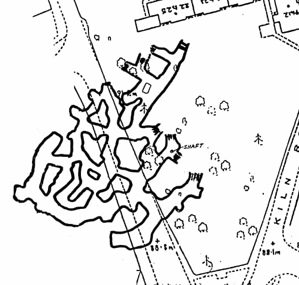
Emmer Green’s principal brickfield and chalk mining site was once generally known as Rose Hill. It lies in the V between Kiln Road and Peppard Road. Already by 1872 (Whitaker, et al.) southern and northern brickyards were referred to at this location. The land has now been built on, accommodating residential development, protected housing, and a scout hut, in Jefferson Close and Wordsworth Court. The site can be conveniently divided into the older southern part, and the newer northern part. There are three distinct accessible sets of mine workings, two of which (the northern mines) partially underlie the land managed by the Scout Association and are connected underground. These northern mines have two extant wide bricklined shafts, which are capped and locked. Harry Pearman (1982) has published sketch plans. One or both of the interlinked northern mines are known to have been used for the secure storage of documents by Reading Council during World War II, and two corrugated iron shelters, a brick-built stove and chimney, and tea-chests are said to remain below ground. One of the shafts reportedly contains timber staging, and one is said to be 70 feet deep. Pearman’s (1991) description of the northern mines notes ‘passages up to 20 feet high’ and averaging 15 feet wide. He recorded that ‘piles of chalk and flint debris cover much of the floors .. most of the flint has been left behind’ (an interesting contrast with the southern mine.) No stepped working faces or mining ‘benches’ were noted. Dates and names on the walls were from the 1890s onwards.
The mine visited (numbered 2 by Pearman) is that in the southern part of the site, and closest to Peppard Road, with a shaft in woodland behind the sheltered housing. This is sometimes referred to as the Hannover Mine (the Hannover Housing Trust owns the site.) The shaft now used for access was rediscovered (Anon, 1977) in 1977 by earthmoving machinery in use on the surface. The site and mine was investigated in the following five years (Anon, 1982.)
The geological survey shows Reading Beds outcropping at this site. The overlying London Clay has been mapped nearby, especially at Clayfield Copse on the eastern side of Kiln Road.
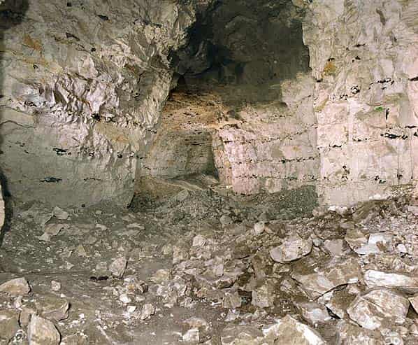
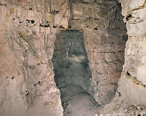
DESCRIPTION OF SOUTH (HANOVER) MINE (PEARMAN’S MINE No. 2)
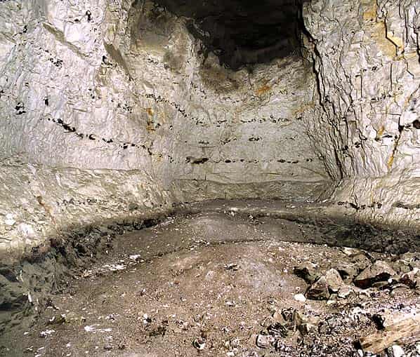
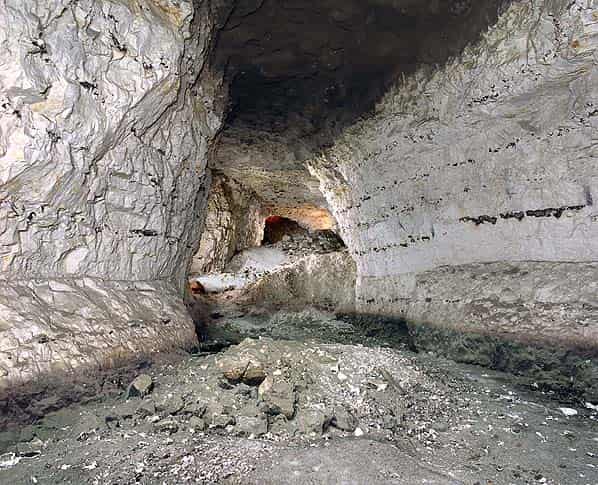
Access is via a fixed steel ladder (c. 16m) in a narrow (1 m) shaft in which an older brick lining is visible as well as a modern corrugated steel lining. This is unlikely to have been an original working shaft, as too narrow, and not well placed for that purpose within the mine. There appear to be some five or six metres of clay overlying the mined chalk. The mine tunnels are generally of the order of five metres high and up to three or four metres wide, although rather higher (perhaps 9 metres) at one point, the deepest in the mine. Floor levels vary by several metres, and original floor is not visible throughout much of the mine. One or two galleries have recognisable low-level miners' ‘benches’ at their ends, although these are often obscured by small chalk debris. The nature and disposition of mine spoil is noted below. The roof support pillars are irregular in shape and size, although to some extent they reflect the jointing pattern.
Material mined
The blocky chalk is in beds of about 0.3 m thickness and upwards, with very prominent layers of flint nodules every 0.4 to 1 m. Such little fallen chalk as was seen included blocks up to 0.3 or 0.4 metres, so could have yielded blocks large enough to have been used as a building stone (as at St. Agnes.) Chalk as lime kiln feedstock for manufacturing quicklime would have to have been of sufficient size (0.1 to 0.2 m) to allow efficient circulation of kiln flames and gases. All other chalk, and chalk smaller than this, would have been quite suitable for agricultural use direct on the fields, and for grinding and mixing with the brick clays for brickmaking.
Jointing and faulting
There are very prominent joints in several places, with what seemed to be at least two distinct orientations. Only at two locations was any vertical displacement noted, in neither case more than about 0.3 metres. Some joint planes have been used to form pillar sides, which obviously saved work in mining, but which raises the question of ceiling stability. Only at one point, however, has one of the very small faults precipitated sufficient chalk from the ceiling to penetrate into the Lower London Tertiary beds above.
Mining spoil
There are prominent layers of flint nodules every 0.4 to 1 metre in the mine walls. Interestingly, very little flint has been left in the mine. One small heap of small broken flints was noted, but most have evidently been taken out, and were probably sold for and used in local buildings, and as roadstone.
Large volumes of small chalk remain on the mine floors. These waste chalk dumps are in part piled up right across mine galleries evidently no longer required for access. In other areas, they are more regularly disposed along one side of a passage, with an access pathway retained alongside.
Transportation and removal to surface
The lined shaft re-discovered in 1977 and currently used for access is clearly only a ventilation shaft. Ormonde (2003) reported what were taken to be cart tracks on parts of the mine floor, possibly implying horse-drawn carts and an adit entrance, although I did not notice such tracks (nor any very extensive length of level floor.) In view of the local topography, a brick-lined vertical haulage shaft (now lost behind a fall) seems the more likely form of main entrance for the mine.
Finds, graffiti, and toolmarks
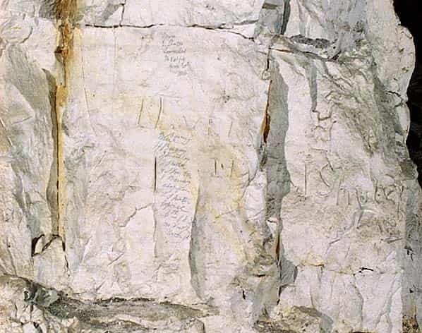
What has been interpreted as a candle-holder remains in the mine - a small tabular piece of chalk about 6 cm across with a central hole. Some artefacts including a part of a clay tobacco pipe (potentially useful as absolute dating evidence) are said to have been found and removed by members of the University of Reading Caving Club. Smoke or soot marks on walls and ceilings are notably not at all prominent (an interesting contrast with the Pinner chalk mine.) Two main sorts of tool marks were seen - the most numerous apparently made with relatively sharp-ended picks, and fewer of a broader nature.
The oldest date seen was 1776, associated with the initials IP (with and without a crossed I.) A concentration of pencilled graffiti including a list of names dated 20th April 1836 appears to reflect an event of some significance, which might have been the last day of operation of the mine. Names and initials noted include M. Valpy, HB, IS, and E. Shuter. There is a Valpy Street in Reading, named after Dr. Richard Valpy, who was headmaster at Reading School 1781 to 1830 (described as ‘a mighty flogger!') In another place was seen C.S. Feb. 3rd 1844 and C. Beavis Mar. 16 1844.
Roof failure
One area near the entry shaft has been walled off, having been found to contain clay and brick debris which has evidently entered a part of the mine which has suffered a crown hole collapse.
At one point a small roof fall, probably initiated by a very small fault (flint bands in the chalk can be seen to have been displaced vertically by about 0.25m) has led to the formation of an upwardly migrating void which now exposes about 1.5 to 2 metres of the Lower London Tertiary beds overlying the chalk. The upper surface of the chalk is irregular and penetrated by boreholes or burrows (it is not clear which) made by former marine animals. These holes are filled with glauconitic green sandy material from the bed above. Immediately overlying the chalk is the Bullhead Bed, a thin layer of unworn but green-coated flints, followed, in turn, by about 0.3 metres of glauconitic sandy (and perhaps clayey) material containing shells and shell fragments, and then grey plastic clay.
There are a few isolated scatters of large chalk blocks which probably fell from the mine ceilings, but overall the accessible parts of this mine appear to be remarkably stable. Unsupported areas of ceiling alongside the major joint planes used as pillar sides should be monitored. Changes at surface, such as extended road and pavement surfaces or new buildings, which might concentrate rainfall into particular locations (especially if those locations coincide with joint planes) might have implications for the mine stability. However, as no solution pipes are to be seen, it appears that the clay cover here adequately protects the accessible mine from water incursion. The mine is generally very dry, with no obvious evidence of water seeping in through the ceiling or standing on the floors.
Ormonde recorded the disappearance of a hut near Brickwall House, near the junction of Kiln Road and Peppard Road, in 1890. This may well have been the original main shaft (inadequately capped) opening up, and is perhaps represented underground by the walled-off collapse.
Other collapses of the surface noted by Ormonde were all quite distant from the brickfield site (at Southdown Road in 1951, about 0.8 km to the south west, Camp Wood to the north a few years later (when a pond and four trees were swallowed up), and gardens at Grove Hill in the 1980s (1.4 km to the south-west.) These may have resulted from natural solution holes on the chalk outcrop unprotected by a Reading Clay cover. Whitaker, et al. (1872) noted a swallow-hole ‘in the valley running up to Emmir Green.’
Site investigation and stabilisation works
Following the rediscovery of the mine in 1977, a new lining was installed in the shaft, and the workings inspected and surveyed by Wimpey.
Investigations revealed the mine to extend below Peppard Road and property beyond it. One exploratory site investigation borehole (c. 0.1 m diameter) was noted. This has been filled with expanded foam, and appears not to be allowing water to leak into the mine, and seems therefore not to be prejudicial to the mine stability. Extensive areas of the mine ceiling, and mines walls at the foot of the entrance shaft, have been shotcreted (some information about this work has been published (Anon, 1991)) The area affected by the suspected crown hole collapse has been walled off behind cement-filled sandbags.
HISTORICAL RECORDS FOR THE BRICKFIELD AND MINE
As Emmer Green fell within Oxfordshire until 1911, records relating to that county need to be consulted as well as those for Reading.
It has been claimed (North, 1986) that Charles I (who lived 1600 - 1649) once took refuge in a 100 foot long chalk cave near Surley Row, in Emmer Green.
The first recorded kiln at the site was in 1645 (or 1654) on what was then called Homer’s Field (Ormonde, 2003.) Robert Plot (1705) noted brickmaking in the locality in 1705, observing that ‘they make a sort of brick 22 inches long and above 6 inches broad.’ One Francis Dormer is recorded as owner in 1842. The 1844 tithe map shews a brick kiln and four other buildings at the mine site.
Hunt (1860) listed 19 brickfields in Oxfordshire, including Caversham kilns, the freehold property of R. Palmer, Esq., M.P., where one John Leach was working Reading Beds and London Clay, and manufacturing 500,000 bricks, 200,000 tiles, 100,000 agricultural (land drainage) pipes, and 20,000 sewage pipes annually. At the same time, he reported (under Berkshire) nine further active brickworks in and around Reading, at the Aldermaston, Beech Hill, Castle, Coley, Erleigh Court, Katesgrove, Reading, Rose, and Waterloo brickfields or kilns. Under Hunt’s ‘quarries’ heading, we find additionally a Mr. Collier listed at the Castle Pit working chalk to be burnt for lime. There are no relevant quarries listed under Oxfordshire. Hunt issued a comprehensive list of brickfields and quarries only for 1858 - there are no comparable lists in earlier or later issues of his Mining records.
Whitaker, et. al. (1872) noted that there was then visible, in the southern brickyard, a section of the clay exploited shewing downfaulted London Clay alongside the characteristically ‘variously coloured mottled plastic clays of the Reading Beds,’ He continued to record that ‘In making a chalk-well on the eastern side of the fault, about 40 feet of clay was passed through before the Chalk was reached, and immediately above the latter there was about 3 feet of clayey green sand (bottom-bed) with oyster-shells at the base. In the other [northern] brickyard the depth to the Chalk is about the same.’
By the Ordnance Survey map of 1877 the southern end of the site is shewn as apparently an abandoned pit, with a bank of kilns alongside Kiln Road. Large-scale brickmaking had evidently migrated northwards a little, where two clay pits, two kilns, and a number of other buildings are labelled Emmergreen Kiln (brick & tile works.)
John Leach was succeeded by Ebenezer Wood, and in 1891 A.C. Brewerton, and later Brewerton and Stevens were in charge, the latter partnership until 1928. One Charles Stevens occupied Brickwall House. By 1935 a limited company had been established, the Caversham Brick and Tile Works Ltd.
Caversham Brick and Tile Works Ltd are listed at Emmer Green in 1933 and through to 1943 in the Quarry Managers’ Journal’s Directory (1933 and 1943), producing Old English tiles, building blocks, bricks, agricultural pipes, whiting, land drain pipes, roofing tiles, and hollow bricks. The firm and site appear to have gone out of business by 1950, as neither are listed in the 1950 - 51 Directory. The production of whiting implies the use both of chalk (either mined on site or bought in) and large volumes of water for processing. Blake’s (1903) recording of a well at the site, over sixty feet deep, had already been noted.
Jukes-Browne and Hill (1904) reported on a large chalk pit (evidently an openwork) at Caversham displaying soft white chalk, with layers of flints three to six feet apart. ‘These flints are black, with a thin white skin; some are cavernous, others in tabular layers; their shape is irregular, generally flattened in the direction of the stratification.’ They assigned the Chalk here to the Micraster coranguinum zone.
A Geologists' Association field excursion visited ‘the brickfield at Rose Hill’ on Saturday, May 13th, 1905 (Monckton and Shrubsole, 1905.) The published report says nothing about the chalk mines, but notes that the clay worked was mostly Reading Beds but also some London Clay, identified by its characteristic fossils and septarian nodules.
The works is thought to have closed in 1947. The land was cleared for redevelopment c. 1977 - 80. Part of Russet Gardens is built within the newer (northern) clay pit.
PROPOSED RESEARCHED AGENDA
Archaeological investigations
The whereabouts of any records made and artefacts removed by the University of Reading Caving Club should be ascertained, and the materials examined. In the event of a sufficiently accurate plan of the mine already existing, this should have added to it (if not already surveyed) the major joints, the disposition of mine spoil and clear walkable pathways, and the several floor levels. The (apparently significantly different) content and the size distribution of the mine spoil should be systematically recorded.
Historical investigations
The only early documentation likely to be worth searching for is amongst Oxfordshire land ownership and estate management records. These might be sought in the first instance in the appropriate record office for the County. More recent papers may be with the current landowners or their solicitors, and with the Land Registry. The early and later geological literature has been well searched, and yields far more for the more accessible Reading itself than for Emmer Green, a long uphill haul! The Geological Survey’s field notebooks and unpublished six-inch maps should be examined. Chalk mines were only subject to government inspection and regulation from the coming into effect of the Metalliferous Mines Regulation Act, 1872, and Inspectors of Mines' Reports for the period up to about 1900 may well be productive. The requirements of the 1872 Act relating to the deposit of plans of mines on their abandonment did not apply to small mines with fewer then 12 men working underground. There may be records relating to surface brickworks created under the Factories and Workshops Acts, 1871, 1891, and 1895 etc. Census returns might be used to assist in the identification of names and initials amongst the graffiti, and to reveal the numbers and names of persons employed in brickmaking, chalk mining, or lime burning at the site. The local authority, Reading since 1911, should clearly possess records relating to rating and valuation and land ownership, and to their wartime use of the mines for document storage. The Companies Registration Office will have had files on the Caversham Brick and Tile Works Ltd, and any other relevant limited liability companies. In the case of defunct companies, their records are likely to have been passed to the National Archive (formerly Public Record Office) under classification BT31. It is likely that surviving Companies Registration Office files will be found to contain only a sample (perhaps one in ten) of the Annual Returns.
CONCLUSIONS
The mine below the southern end of the Kiln Road / Peppard Road site appears to have been associated with the earliest industrial use of the land here, with its origins possibly as early as the 17th century. At some time in the 19th century this end of the site was abandoned, and the focus of clay digging and chalk mining shifted northwards. Most of the flint necessarily removed in getting the chalk has been taken out of the south mine, and probably used in local buildings and for road-making, but according to Pearman left underground in the north mines. The presence of large volumes of small chalk spoil, which would have been perfectly usable in brickmaking or for soil dressing, left in the mine suggests that at the time it was worked the mine was primarily for chalk for lime-burning, either for agricultural use for making mortar. The use of ground chalk as an additive to the clay in brickmaking may have been a later development. The presence of chalk block internal walls in at least one house in the neighbourhood suggests that to some extent the mine was also worked as an underground quarry for building stone.
Whitaker’s mention, in 1872, of an evidently relatively recently made chalk well, appears to indicate some activity at the southern site significantly later than the 1830s. The fact that the Caversham Brick and Tile Works Ltd were manufacturing whiting in the 1930s and 1940s indicates the probability that chalk mining was still taking place at that date.
The mine is dry and quite stable, probably protected by its impervious clay cover. Those areas most likely to collapse (probably in the neighbourhood of an original haulage shaft which was inadequately capped and which allowed water in) have now collapsed. The existing shaft should be safeguarded against the ingress of water, and areas of unsupported ceiling adjacent to fault plane sided pillars should be monitored. Further developments at surface (such as extended paving or roadways) which might concentrate rainwater on particular points, should be avoided. The system appears to be at least as sound as the Chislehurst ‘Caves’ in south London, an extensive chalk mine of comparable age which has for over a century been used without mishap as a tourist attraction and (in wartime) for storage (WWI) and as an air raid shelter (WWII.)
Sources:
- ANON, 1977, Huge hole found under homes site. Reading Evening Post, 5 May 1977.
- ANON, 1977, ‘Secrets’ rot away down the mines at Emmer Green. Reading Chronicle, 30 September 1977, page 3.
- ANON, 1982, ‘Black Hole’ becomes a right royal mystery. Reading Chronicle, 6 August 1982.
- ANON, 1982, Geologists seek out ‘black hole’ secrets. Reading Chronicle, 30 July 1982, page 5.
- ANON, 1991, Crack shot. New Civil Engineer, 24 January 1991, page 29.
- BARBER, Martyn, David FIELD, and Peter TOPPING, 1999, The Neolithic flint mines of England. English Heritage / Royal Commission Historical Monuments (England): xiv + 95pp [ISBN 1-873592-41-8]
- BLAKE, J.H., W. WHITAKER, and H.W. MONCKTON, 1903, The geology of the country around Reading. Memoir Geological Survey: 91pp
- CARTER, H.H., 1979, Mining for chalk. Reading Naturalist 31, 16 - 17.
- EDMONDS, C.N., 2001, Subsidence hazard in Berkshire in areas underlain by Chalk karst. IN: James S. GRIFFITHS (edr), Land surface evaluation for engineering practice. Geological Society of London Engineering Geology Special Publication 18, 97 - 106 [ISBN.]
- HUDLESTON, W.H., 1876, Excursion to Reading - June 3rd, 1876. Proc. Geologists' Association 4(8), 519 - 523 [Caversham, Coley, and Katesgrove were visited]
- HUNT, R., 1860, Mining records. Mineral statistics. Mineral statistics of the United Kingdom of Great Britain and Ireland. Being Part II. for 1858. Memoir Geological Survey, pages 61 - 62.
- JUKES-BROWNE, A.J., and W. HILL, 1904, The Cretaceous rocks of Britain. III. The Upper Chalk of England. Memoir Geological Survey (pages 217 - 218)
- MATHERS, S.J., and N.J.P. SMITH, 2000, Geology of the Reading district - a brief explanation of the geological map Sheet 268 Reading. British Geological Survey: ii + 30pp [ISBN 0-85272-362-8]
- MONCKTON, H.W., and O.A. SHRUBSOLE, 1905, Excursion to Reading and Caversham, Saturday, May 13th, 1905. Proc. Geologists' Association 19(3), 135 - 137.
- MOORE, D.M., 2000, Earthquake worry! Reading Evening Post, 19 June 2000.
- NORTH, Leslie, 1986, The history of Surley Row. Reading Chronicle, 11 April 1986.
- ORMONDE, Margaret, 2003, Emmer Green past and present from estate hamlet to village to suburb. 2nd edn. Reading: Emmer Green Residents' Association / Map Reading: 120pp [The date for the first kiln is given as 1654 on page 18 but 1645 on page 87][ISBN 0-9534436-6-3]
- PARLIAMENTARY GAZETTEER, 1842, The Parliamentary gazetteer of England and Wales. 1840-4. Glasgow: A. Fullarton & Co. [This 12 part work, despite its title, was a commercial not a governmental publication]
- PEAKE, A.E., 1913, An account of a flint factory, with some new types of flints, excavated at Peppard Common, Oxfordshire. Archaeological Journal 70, 33 - 68.
- PEARMAN, Harry, 1982, Emmer Green chalk mines - Berks. Records Chelsea Speleological Soc. 11, 34 - 36 [Includes two sketch plans]
- PEARMAN, Harry, 1991, Emmer Green, Berkshire - chalk mines. Newsl. Kent Underground Research Group 31, 1 - 2.
- PLOT, Robert, 1705, The natural history of Oxfordshire, being an essay towards a natural history of England [It should be noted that this edition of this work by Robert Plot [1640 - 1696] was published posthumously, having been first published in 1677; it should be determined, therefore, if brickmaking at or near Emmer Green was referred to in the earlier edition, or can be ascribed to subsequent note by the author or subsequent additions by a later hand]
- QUARRY MANAGERS' JOURNAL LTD, 1933, The directory of quarries, clayworks, sand and gravel pits, &c. 5th edn. Quarry Managers' Journal Ltd, page 74.
- QUARRY MANAGERS' JOURNAL LTD, 1943 / 44, The directory of quarries, clayworks, sand and gravel pits, &c. 10th edn. Quarry Managers' Journal Ltd, pages 44 and 198 [This is dated 1943/44 on the front cover, but 1944/45 on the title-page]
- QUARRY MANAGERS' JOURNAL LTD, 1951, The directory of quarries, clayworks, sand and gravel pits, &c. 12th edn. 1950 - 51. Quarry Managers' Journal Ltd.
- SHEPHERD, Robert, 1980, Prehistoric mining and other industries. London: Academic Press: xii + 272pp [ISBN 0-12-639480-6]
- WHITAKER, William, H.W. BRISTOW, and T. McK. HUGHES, 1872, The geology of the London Basin. Part 1. Memoir Geological Survey, page 202.