")
")
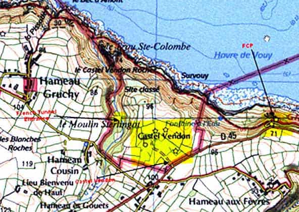
In 1924 the French Navy ordered several 13.4 inch (34cm) turret-mounted guns from the arms manufacturer Schneider. The guns were to be added to naval bases on the coasts of Tunisia and Algeria and further south at Dakar. In addition, two similar guns in twin turrets were to be added to the coastal defences around Cherbourg and the site chosen was Castel-Vendon, 5 miles west along the coast from Cherbourg. The guns which would have had a range of nearly thirty kilometres arrived at Cherbourg in 1928 but because of cuts in defence spending they were put into storage at the naval base.
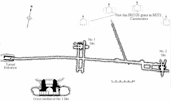
In 1935, as war clouds began to gather over Europe, France rapidly began to strengthen its defences and work started at Castel-Vendon. Two concrete ‘silos’ were built to mount the guns a short distance back from the cliffs; these were connected by tunnels and had underground accommodation for personnel and munitions for the guns stored at Cherbourg. The work had not been finished and the guns had not yet been installed when the German forces arrived at Cherbourg in July 1940.
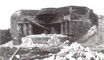
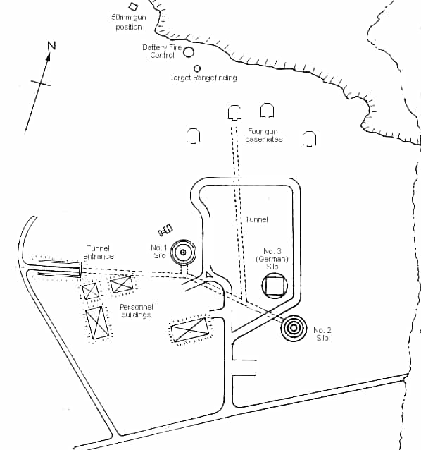
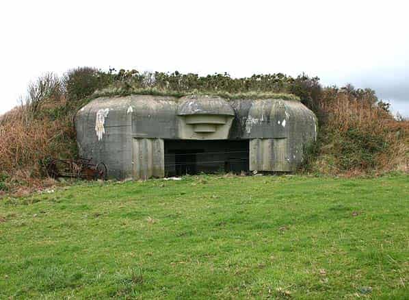
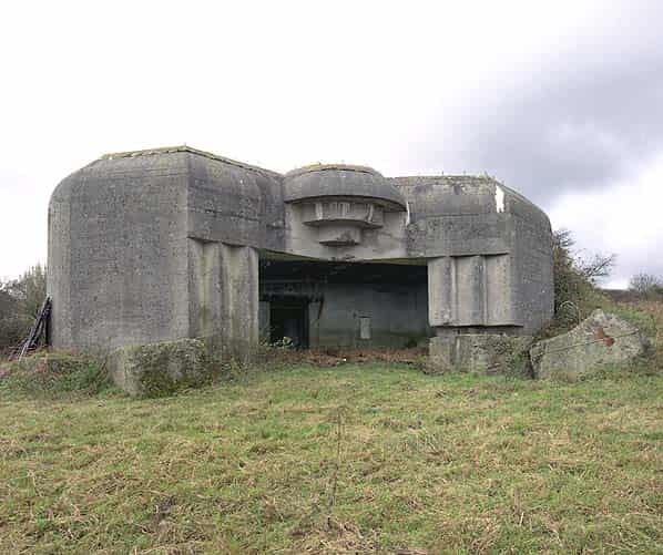
Silo 1 was complete but not fitted out, Silo 2 was partially complete and the underground workings were about 75 per cent finished. In 1942 the Germans started work at the site, initially as part of the West Wall, and added a battery of four Skoda 6 inch SKC/28 guns in separate M272 concrete casements, together with two 2 inch guns and range-finding bunker on the edge of the cliffs. A two level M162A fire control position was planned but this was never built. The main battery was between the silos and the cliffs.
It is unclear what happened to the two guns. They may have been scrapped and melted down before the war but this seems unlikely. Had they fallen into German hands they would certainly have been used.
It has been suggested that the partially finished French silos were later used by the Germans as a launch site for V2 rockets.
This however is not true. Silo 1 could not accommodate a V2 rocket vertically because, although it was wide enough, it was only 37 feet deep, compared to 45 feet required for a V2.
Silo 2 could not accommodate a V2 because, although it was deep enough at 55 feet 10 inches the diameter of the lower 19 feet 10 inch section was only only 7 feet which was too narrow for a V2 with fins fitted.
The lowest level of this silo was blocked with two steel beams, effectively providing a floor at the 55 feet 10 inch level.
A third silo is also to be found close to Silo 2. French plans of the site do not show a third silo and therefore it was assumed to have been built by the Germans. This was of similar dimensions but was roofed over at ground level with access steps leading downwards at one edge.
There is no doubt that the site was inspected by the Germans after July 1940 and the original French work would certainly have been of interest. From 1943 suitable V-weapons sites were being inspected in northern France and there is a good chance that Castel-Vendon was noted for inclusion in the site building programme. The presence of the coastal battery provided perfect camouflage, since Allied Intelligence was concerned with V-weapons and so showed no interest in additions to the West Wall fortifications.
The differences between Silos 1 and 2 raises the question of why they had different dimensions when the two turrets they were originally intended for were presumably identical. The existence of Silo 3, with a similar outer diameter to the other two silos but not shown on French plans, indicates that something other than West Wall fortifications was planned for the site.
A Rheinbote is the only rocket that would conveniently fit the dimensions of Silo 2 and the Rheinbote could be launched vertically (although this reduced its range to less than 100 miles) but there is no evidence that any of the three silos were ever used for launching rockets so the WW2 use of the two French and the later German built silo remains a mystery.
Since the Second World War Castel-Vendon has been under the control of the French Navy and current maps still show the site as military land with a large exclusion zone fanning out into the English Channel. When visited in 1974 the site appeared to be abandoned and large sections of the perimeter fencing had disappeared. Today the site still has signs around the perimeter indicating that it is military land but there is no evidence that it is ever used as a firing range.
The silos are contained within three separate barbed wire fenced areas which is now heavily overgrown making access difficult. The remainder of the land, including the three remaining casemates is used for grazing horses, the fields being separated by a low voltage electric fence.
The main entrance to the site is from the D45 road where a low metal gate gives access into the site.
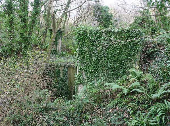
Three of the four concrete casemates are still standing and are in good condition. Today they are used as a shelter for the horses. Casemate No 1 has been has been completely destroyed. The Battery was fired on by a British and American Task Force just before its capture.
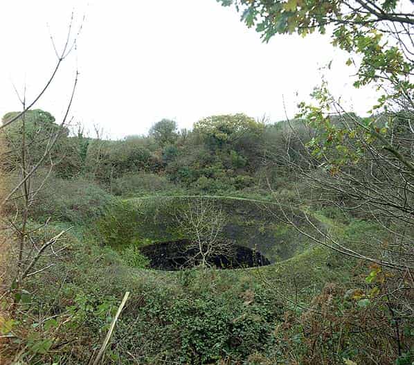
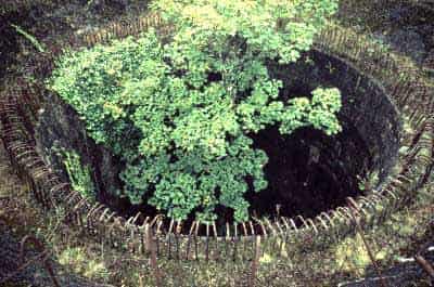
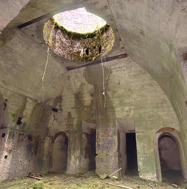
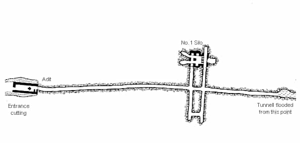
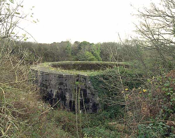
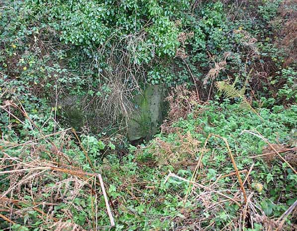
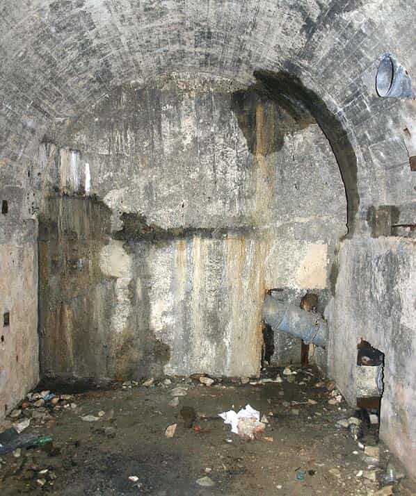
Silo No. 1 is set at the bottom of a 15 foot depression; because of the dense undergrowth it is not possible to see it from any of the paths round the site. It consists of a wide gently sloping concrete rim flush with the ground and about 50 feet in diameter. The silo itself is about 25 feet deep with vertical sides. In the centre there is a hole, 6 feet in diameter, down to an arched chamber below. Silo No. 2 is of similar diameter and also set in a 15 foot deep depression. This silo however is not flush with the ground standing some 8 feet high with vertical sides. A ring of exposed reinforcing bars indicates that this silo was never finished.
Silo 3 has a concrete roof which itself is overgrown and difficult to access. A set of concrete steps lead down through an archway to a curving sunken path to the bricked up personnel entrance into the side of the silo. There is no evidence that this silo ever linked into the network of tunnels below.
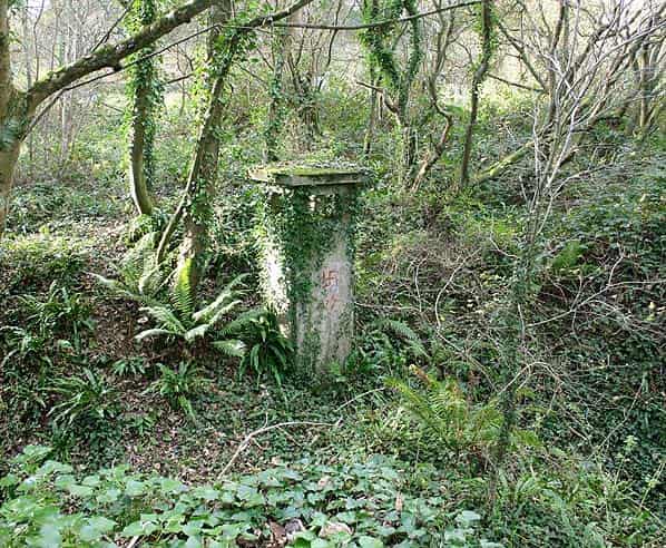
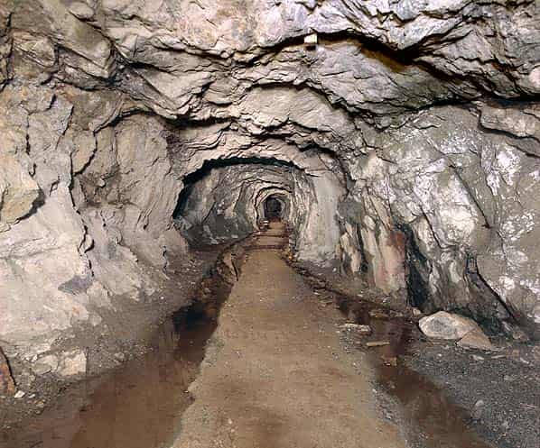
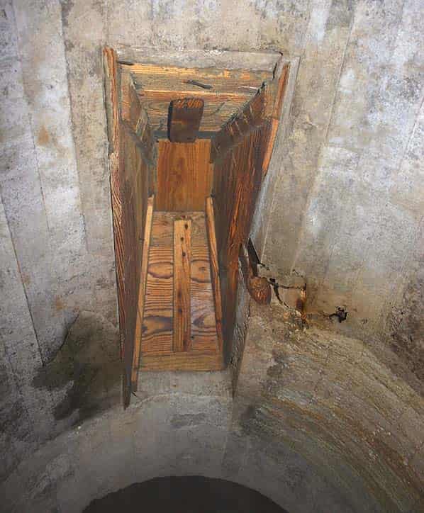
The entrance into the tunnel network is on the east side of a minor road running north from the D45 towards Gruchy. Turning north off the D45, the road crosses a small wooded valley after about 200 yards. The entrance to the tunnels is on the east side of the road where there is another barely readable sign indicating ‘Terrain Militaire’. A number of concrete structures can be seen close to the road, one of these is a ventilation tower up from a network of buried culverts that presumably drain the tunnel network. Water can clearly be heard flowing some 20 feet below.
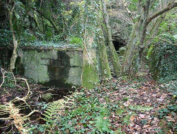
A wooded cutting leads towards the tunnel adit at the base of a rocky bank. Close to the adit there is a large concrete block. Its purpose is unknown but it would prevent vehicles from approaching the adit.
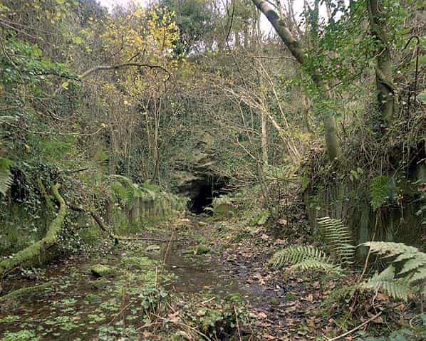
The entrance to the tunnel system resembles a mine adit and it has been suggested that the tunnels were part of a former tin mine of which several were known to exist in the area. There is no visible mineralisation or other evidence to back this theory and it is more likely that the tunnel was constructed specifically to access the gun turrets. Military tunnels were often excavated by former miners.
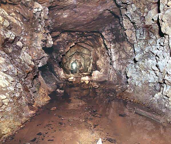
The main entrance tunnel is unlined throughout and although there is a little water at the entrance it is dry for most of its length. The tunnel runs eastwards for 100 yards to a crossroads. To the right there is a blind end after forty yards. Straight ahead there is deep water. In Alain Chazette’s book ‘Antlantikwall’ this tunnel is shown heading towards Silo 2 with a long branch ending close to the rear of No. 2 casemate. If this is correct this tunnel must be at a lower level and is presumably now flooded. There is no evidence at the rear of No. 2 casemate where the tunnel emerged but this area is heavily overgrown and might hide some concrete remains of the entrance.
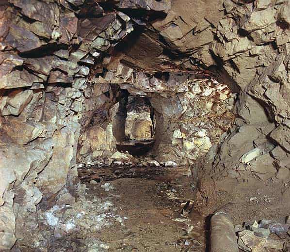
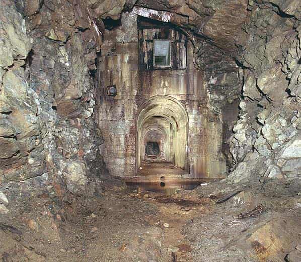
To the left of the crossroads there is a section of concrete lined tunnel after twenty yards with several arches on the right hand side into the chamber at the base of the silo with the 6 inch diameter hole out to daylight in the vaulted roof. A second concrete lined tunnel leads from the far side of the chamber back towards the main entrance tunnel.
There is little metal to be seen, a few pipes, probably part of the ventilation system and some of the wooden shuttering is still in place embedded in the concrete indicating that the structure was never completed. Some ventilation trunking can also be seen high in the wall. There are also a number of side chambers some concrete lined and others unlined.
The site is a bat hibernaculum and a large number of bats of various species were noted in the entrance passage so access to the tunnel network is not advised during the hibernating season, December - March.
Sources:
- ‘Hitler’s V Weapons Sites’ by Phillip Henshall ISBN0-7509 2607-4 - Sutton Publishing 2002
- ‘Atlantikwall’ by Alain Chazette, Alain Destouches & Bernard Paich ISBN 2 84048 088 3
- Atlantikwall.co.uk
- The Atlantikwall in Normandy
- Bunkersite