HISTORY
There is little documentary evidence relating to the early history of Cae Goch Sulphur Mine and suggested mining during the Roman occupation cannot be confirmed. The first written reference to mining at Cae Coch is a letter written by Sir John Wynn in 1607 referring to a mine with “great store of brimstone (Sulphur). It may be digged at a small charge and lies within two bowshots of a navigable river which, within seven miles, empties itself into the sea”
The next written evidence of the mines existence is at the end of the 18th century when a letter from Robert Owen describes the Pyrites Mine at Cae Coch “at a stand for twenty-five years until a new company came to investigate the prospect in 1817.” Production at the mine was on a small scale until rapid development of the alkali manufacturing industry after 1820 brought prosperity to Cae Coch.
The mine was acquired by chemical manufacturers, Thompson & Hill, who were in the process relocating their sulphur manufacturing activities from their old works at Wapping to a new and more productive works at Vauxhall in the port of Liverpool. This was to mark the start of a boom period for Cae Coch.
Initially mining remained on a small scale with only two face workers and two surface workers employed.
The first pyrites was ready for shipment in June 1821, a mere 100 tons and the result of several years labour.
Production of pyrites from 1821 to 1833 stayed at around twenty tons per month, with almost the entire output being shipped direct to Liverpool. From 1834 production increased to about eighty tons per month until 1843 when it was reduced to about thirty tons per month.
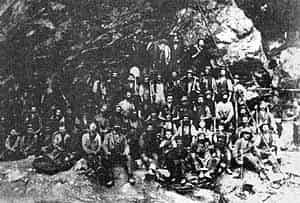
Between 1851 and June 1878, under new ownership, production was once again increased a little over thirty thousand tons of pyrites being shipped to Liverpool. This represented an output in most years of over a thousand tons interrupted briefly in 1856 when a large roof-fall halved normal production and for a period of years during the early 1860s during the American Civil War when normal production was cut back by around one third. In a good year production reached 17,000 tons with a workforce up to 32 men.
In March 1880 the lease for the mine, now extending to some forty-four acres, was sold to William Veitch, a chemical manufacturer from Crieff, Scotland. Veitch also had an interest in the Liverpool chemical industry to where the pyrites continued to be despatched. He was quick to introduce improvements at the mine, building an incline down to the turnpike road running through the Ddu valley. Production was subsequently increased to a peak in 1885, when one hundred and nineteen men produced nine thousand four hundred and forty-three tons of ore.
Those figures were never achieved again but production remained steady until Veitch left the mine in 1895, by which date a total of 81,634 tons of pyrites had been extracted since his arrival in 1880.
During this period Veitch tried to sell the mine on three occasions finally selling it at the third attempt to the North Wales Sulphur Mining Company in 1889, he stayed on as an employee.
The new proprietors introduced electricity in 1890 after installing a turbine driven by a new leat from the Afon Ddu but they abandoned their operations five years later and the mine remained idle for several years. There were a number of short term leases but little serious sustained production until a new phase of interest and activity during the First World War.
With the coming of war in 1914 all British mines that might provide strategically important minerals were investigated. Cae Coch fell into this category as sulphur is an important ingredient in the manufacture of munitions. An initial examination by the Department of Mineral Resources in 1915 came to the conclusion that the sulphur content of the pyrites was too low to justify re-opening the mine, but as it became increasingly difficult to import satisfactory material, this decision was eventually reversed.
By 1917 the Government was prepared to act on its own estimates, which suggested that the mine could be made to yield some two to three thousand tons of pyrites per week with a 42% sulphur content.
The mine was acquired by the Ministry of Munitions under the Defence of the Realm Act and in January 1917 exploratory work began. By June of that year the workforce of two hundred and thirty, constructed power plant, installed compressors, and erected a crushing mill and aerial ropeway to carry the pyrites across the Conwy valley to the railway line. Between May and December of 1918, some 15,951 tons of pyrites were sent from the mine, just over half the total output from all mines in the UK.
With the end of the war, the mine ceased production in January 1919 and remained idle until the build up to hostilities in 1939 when it was once again considered as a useful source of sulphur.
Investigation at Cae Coch was initiated in 1940 by Sulphuric Acid Control, a Department of the Ministry of Supply. By the end of that year a number of reports had been prepared for the Governments' Non-Ferrous Metallic Ores Committee, pertaining to the potential contribution of Cae Coch to the war effort. The report advised that an output of 30,000 tons per annum was considered feasible and it was decided to go ahead with exploratory work to ascertain the reserves available.
The underground work was started in August 1941 by the British (Non-Ferrous) Mining Corporation Limited, acting as agents for the Non-Ferrous Metallic Ores Committee.
During the first month the workforce concentrated on clearing the levels, laying tracks and installing compressed air pipes. There was a shortage of available labour however; the local Labour Exchange had no able-bodied men on the books and an approach made to the War Office for Italian prisoners-of-war to work in the mine (as happened at Greenside mine in the Lake District), was not acted upon.
The thickness and sulphur content of the pyrites proved inconsistent and a decision was taken to close the mine on the 14th of May 1942.
Sulphur continued in short supply for some time after the war, and Cae Coch was classified as an emergency reserve although no further underground work was undertaken. A two year exploration licence was granted to John Taylor & Son in 1957 and British Titan Products of Billingham, County Durham, drilled four boreholes in 1966. However, there was no follow-up by either company, no substantial reserves of pyrites having been found and the mine continues to lie abandoned
GEOLOGY
The ore body at Cae Coch consists, in the main, of a two metre thick bed of massive quartzitic pyrites, sandwiched between the underlying Dolgarrog Volcanic Formation and the overlying Llanrhychwyn Mudstones, which are both Ordovician in age
This deposit is a major source of pyrites in Wales. Pyrites in its pure form contains 46.6% iron and 53.4% sulphur and it was for the sulphur that the Cae Coch deposit was worked, 70% iron content being found in the haematite ores worked extensively in Cumbria and Lancashire, which made them more attractive to the iron miner. The Cae Coch pyrites was not pure, typically containing 30% to 40% sulphur, with correspondingly less iron content.
The Cae Coch deposit consists of two separate ore bodies. The smaller northern body outcrops to the east of Blaen-y-wern, whilst the larger and more extensively worked lies immediately to the south.
The southern ore body has an average dip of thirty degrees to the south, with the superimposition of minor folding creating localised flattening or steepening of the pyrites which is clearly visible in the workings.
THE WORKINGS
The workings have been accessed by four main adits, No. 1 at the top of the hill, entering the northern ore body and Nos. 2, 3 & 4 entering the southern ore body. The No.2 adit provided access into the extensive pillar and stall workings of the main mine while the Nos. 3 & 4 were principally driven to drain the workings at depth.
The earliest workings are probably those of the linear quarry which follows the outcrop of the northern ore body to the east of Blaen-y-wern. The workings on the larger southern ore body also began as a quarrying exercise until continued removal of the overburden became impracticable after which the deposit was exploited by a series of adits; the most important of these being the No.2 adit.
SITE VISIT REPORT
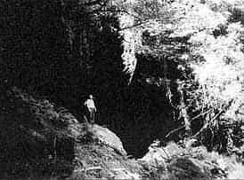
The mine lies on Forestry Commission land and unlike many other mines in the Gwydyr Forest has not yet been gated. Access to this mine can be achieved via the forest road which leaves the B5016 Conwy to Trefriw road a short distance north of the Trefriw Spa. We decided to access the Mine from the upper road from Trefriw which eventually peters out to become a footpath at Tyddyn Wilym. In hindsight, might have been a mistake as the path down to the mine is steep, overgrown in places and badly signed. The footpath is clearly signed by a cattle grid in the road and surprisingly there was room to park our convoy of nine cars. The footpath heads in the direction of an occupied house but it isn’t obvious that you have to walk up the drive of the house turning right as you pass it into a field that appears to be part of the garden. There is a gate at the eastern side of the field and this is the way on, descending steeply into a wooded area where a small open quarry is soon reached. This is the earliest upper working of the mine extracting ore from the northern ore body. At the bottom of the quarry No. 1 adit is clearly visible; this gives access to the upper underground workings but the adit was badly silted so we decided not to investigate as time was pressing.
A short distance down hill there are two further adits, one is dry and extends for about 20 yards to a blind end, the other has foot deep water at the portal and runs west for some fifty yards and then turns south for a further fifteen yards where the water deepens at the blind end; both were probably exploratory drivages.
From this point the footpath turns to the south and drops steeply down hill towards a fence line which has a number of notices fixed to it describing ‘dangerous old mine workings’ The footpath turns south west along the fence line and in a gully on the left hand side of the path the sheave wheel for the top of the 1917 aerial ropeway is still in place. On the opposite side of the footpath are the footings of a small building straddling the fence.
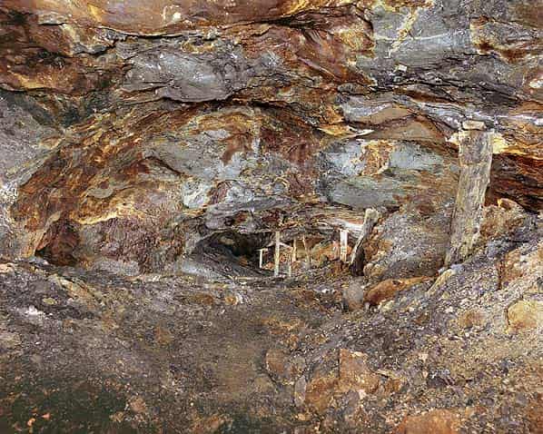
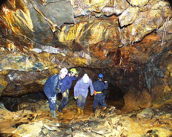
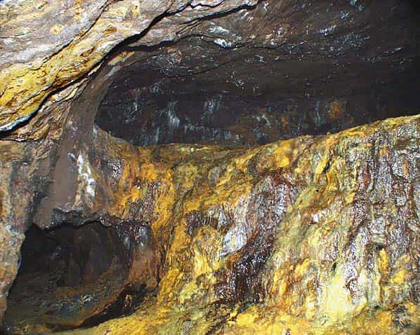
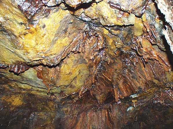
No. 2 adit is obscured by bushes at this point but by climbing over the fence and into the undergrowth it quickly becomes apparent. It is not an adit in the normal sense of the term but resembles a huge cave entrance thirty feet in height and as many wide. The adit opens immediately onto the steeply upward dipping pillar and stall workings in the lower ore body.
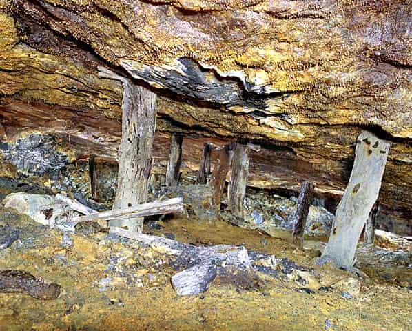
The pyrites bed was worked by leaving pillars from two to three yards in diameter, at
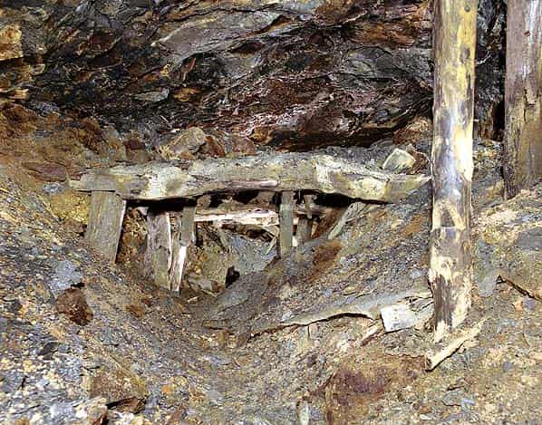
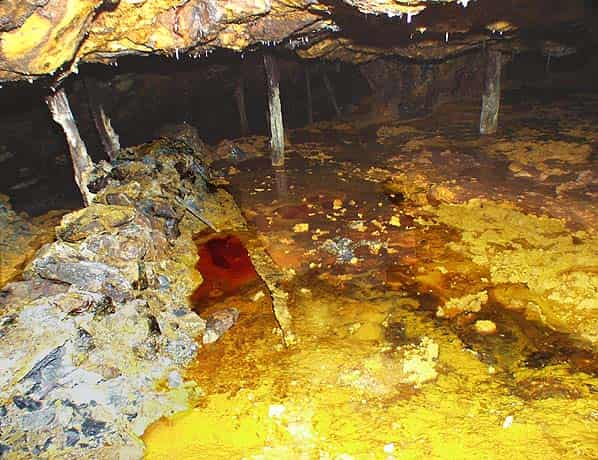
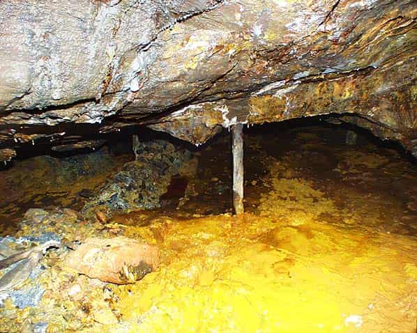
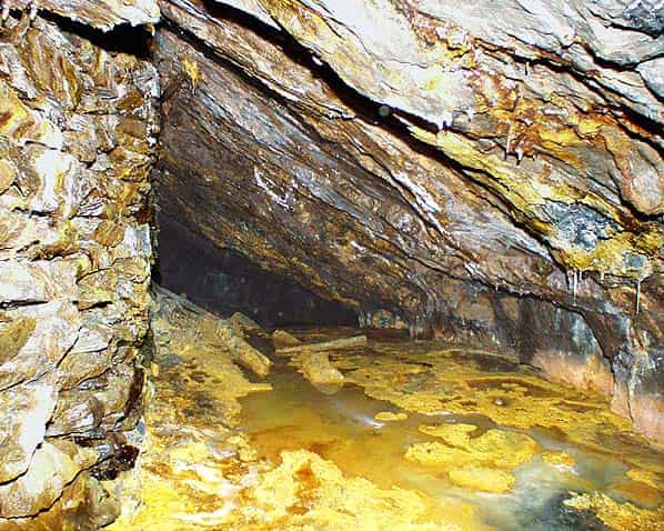
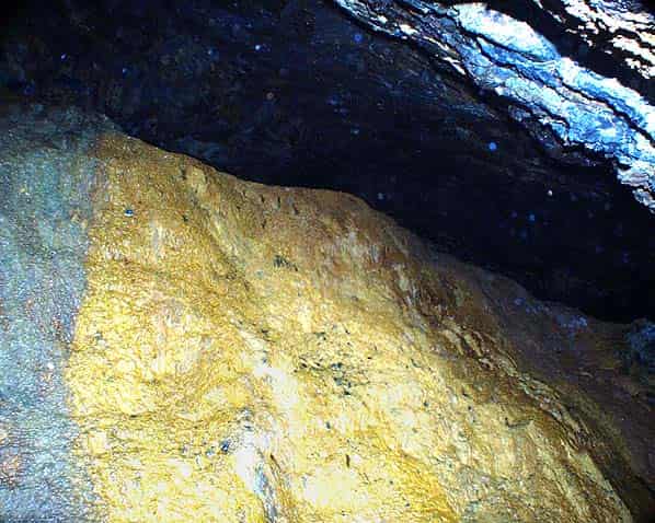
approximately eight to ten yard intervals. The pillars are irregular in shape and spacing, where the roof is stable a greater distance between pillars can be achieved without support. Where the roof is weaker the pillars are left closer together and are supplemented in some areas by a large timber pit props which are now doing little to support the roof, there are numerous roof falls, some apparently quite recent. In one area, up dip from the entrance the roof has fallen away around timber arching which is still left standing. Small electrical insulators fixed to the walls indicate that an electrical supply was taken deep into the mine.
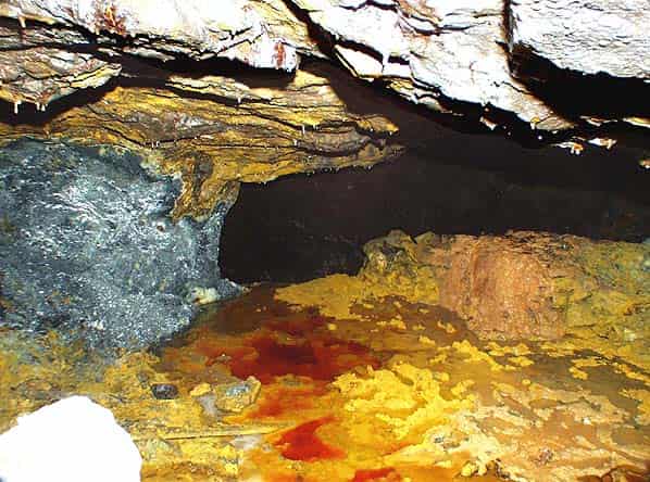
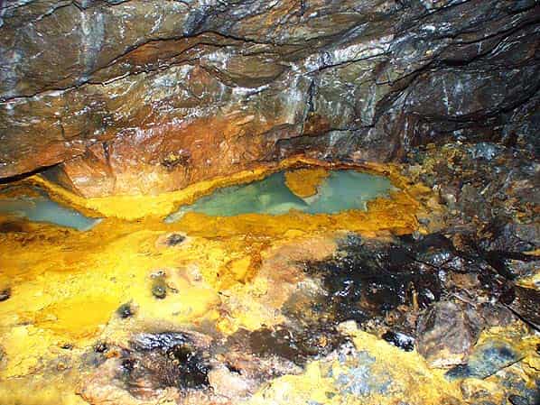
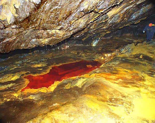
There are many calcite formations and some spectacular colouring in the rock and in several places there are acid pools that leave permanent stains on boots and clothing. The lower levels of the mine are flooded up to the level of No. 2 adit and are no longer accessible.
At this point we had to retrace our steps but we will return to Cae Coch another day, there is plenty more to see underground and on the surface much remains including the inclines, drum house, storage bins, foundations of the processing mill, numerous other buildings and Nos. 3 & 4 blocked drainage adits.
Sources:
- The history and geology of Cae Coch Mine is an abridged version of Mines of the Gwyder Forest Part 7 by John Bennett & Robert Vernon pages 12 - 39. ISBN0 9514798 6 5. It is reproduced with permission from the author.