The final stage of the ROTOR Programme (Rotor 3) was to provide radar cover for the north and west of the British Isles which were still exposed to attack and to give low and surface level cover over the Atlantic, the absence of which prevented effective action against low flying enemy aircraft. Three new CEW stations were to be built at Aird Uig, Faraid Head and Saxa Vord equipped with Type 80 Mk 2 and Type 13 radars. The new CEW operations buildings were to be above ground, heavily built and designated R10, similar in internal layout to the underground R1 bunkers.
Rotor 3 included five new Chain Home Extra Low (CHEL) stations equipped with Stage 1 radar equipment to enable detection and tracking of low flying aircraft. (Stage 1 comprised Type 7 Early Warning [E/W] GCI , Type 14 E/W search radar E/W or Fighter Control [CEW station], Type 13 H/F and a Type 15 [mobile Type 7] - radars from this list were installed as required) The proposed stations were at Kilchiaran, Murlough Bay, Prestatyn, Snaefell and West Myne. These were to be heavily built operations blocks, designated R11; the above ground version of an R2 bunker.
Two new GCI stations were also proposed as part of the Rotor 3 programme, each equipped with a Type 80 radar and R8 prefabricated operations block. One at Ballywooden (Killard Point) in Northern Ireland and the other at Wick on the Scottish east coast.
It was hoped that The ROTOR 3 programme would be complete by 1957 and all technical aspects were classified as ‘Super Priority’.
The site selected for RAF West Myne was North Hill between Minehead and Porlock. The site is owned by the National Trust who initially refused permission to build the radar station on their land. The Air Ministry insisted and eventually, the National Trust relented on condition that the Royal Arts Commission approved the design. They imposed numerous conditions relating to the appearance and positioning of the buildings. The County Council was also involved in granting planning permission resulting in a prolonged consultation period.
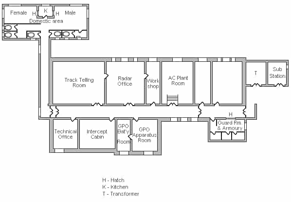
In order to appease the RFAC, the Air Ministry considered using a prefabricated R8 technical block (normally used for a GCI station) as it might be less obtrusive than a hardened R11 building but they eventually settled for a standard R11, the only building of its type in mainland England (others are in Scotland, Wales, Isle of Man and Northern Ireland).
In a letter to the RFAC on 29th March 1954 the Air Ministry stated “we are providing the smaller buildings with pitched roofs and the two large buildings (the R11 technical block and standby set house) with flat roofs screened by low parapets”
This did not satisfy the National Trust and RFAC, the local NT agent pointed out that as the buildings were on top of a hill they should be as low as possible. The design of the R11 was considered unsatisfactory and it was suggested that the intake transformer house and sub station should be combined with this building, the Air Ministry agreed to consider this. It was agreed that the foundation blocks for the Type 14 radar gantry should be sunk into the ground which would lower the structure by 3 or 4 feet, the Type 13 plinth would also be sunk..
A National Trust site visit in May 1954 suggested that the whole site should be moved further downhill but on 21st May 1954 the RFAC committee finally agreed to the Air Ministry’s proposals.
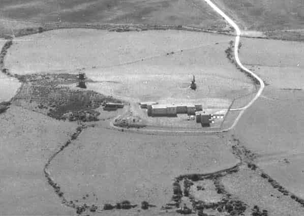
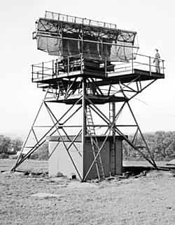
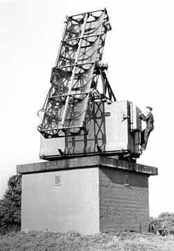
By April 1956 the station was almost complete with a Type 14 radar on a 35' gantry and a Type 13 height finder on a 9' plinth. The station was equipped with 6 Type 60A consoles, 1 Type 61 console and 2 video map units.
Remote ‘small’ VHF transmitter and receiver blocks were provided, both were at at Bratton Ball 1 1/4 miles south east of the technical site (transmitter at SS942475 and receiver at SS945474). No domestic camp was provided with personnel being billeted in hotels in Minehead'.
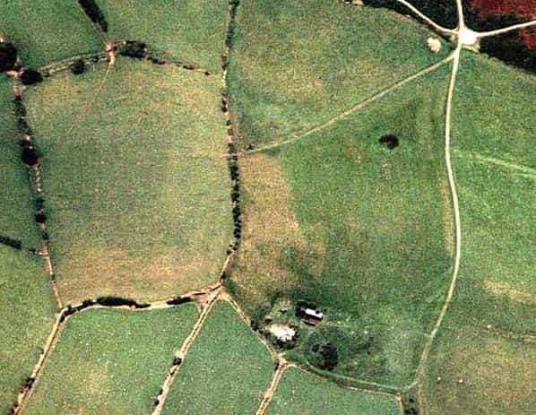
By the target completion date of April 1956 some ROTOR stations had already closed down and the introduction of the ‘Comprehensive Radar Station’ as part of the ‘1958’ plan had no place for West Myne. Despite the large outlay, the station had a very short operational life. After closure the buildings were immediately demolished and today the only evidence is the road that led to the site and a large flat area about 35 metres in length which was the site of the R11. There is also an area of concrete that is probably the base of one of the ancillary buildings.
Sources:
- Bob Jenner
- Somerset Historic Environment Record - Somerset County Council
- PRO Files: Air 20/11323, Air 8/1630