Seaton Snook Radar Station was developed during the war as a Ground Control Intercept (GCI) A Station with 1 Type 7 and 1 Type 21 radars. In 1945 the station was still operational and its future was required by fighter command (AIR 25/686). It’s name was changed to Billingham and on 5.9.1950 (AIR 2/1178) reverted back to Seaton Snook.
It was chosen to participate in the post war ROTOR programme continuing in its GCI role with an ‘R3’ two level underground control centre which opened on 5th June 1953. The station was initially fitted with 1 Type 7 Mk. 2, 2 Type 13 Mk. 6, 3 Type 13 Mk. 7, 1 Type 14 Mk. 8, 1 Type 14 Mk. 9, and 1 Type 11 (M) Mk. 7 radars. When a Type 80 was brought on line in the mid 1950’s the two Mk 14’s were removed. The station was operated by 59 Signals Unit. With the demise of ROTOR the station was still required for the 1958 reorganisation ‘plan ahead’ (AIR 8/2032). At an unknown later date the site became redundant and was disposed of.
The site was acquired by Able UK Ltd in the late 70s. The bunker was flooded but after pumping the upper floor dry the company used it for the storage of demolition explosives and each room had protective flash proof lighting installed. With continued water ingress they were eventually forced to abandon it.
They currently operate a clay extraction and landfill operation. The clay is extracted leaving a 20m deep pit which is then used as a landfill. When the clay has been exhausted and the excavations filled the whole site will be domed with earth and turned into a nature reserve. The R3 bunker was very shallow and covered by a very prominent earth mound, the Guard House was of the standard design, faced in brick. By 1984 it was derelict and in a dilapidated state with no roof timbers, doors or windows. The brick walls around the stairwell had been removed but the access tunnel was still accessible as was the whole of the upper floor and the emergency exit stairs, the lower floor was flooded to the top of the stairs. By 1988 the water had risen flooding the bottom end of the access tunnel and by 1990 the stairwell at the rear of the guardhouse was also flooded. The guardhouse has now been completely demolished together with the remains of the stairwell down to the access tunnel, but its location can be located as the rubble has not been cleared away.
The Type 80 modulator building was being used as a snack bar by the site workforce in 1980 but by 1988 only one end wall remained and all traces of the building have now disappeared.
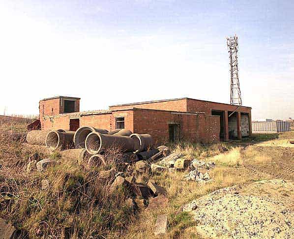
The WW2 Happidrome still exists in poor repair and has been used as a site office and workshop but is currently unused.
A significant amount of earth has been removed from the area exposing the top of the R3. A vehicle ramp has been built and the portacabin offices and mess rooms stand on the exposed concrete. The top of the bunker now stands some 3 metres above the ground. The main ventilation shaft still stands in the corner and although in poor condition it retains some of its louvers. Mesh has been fixed across the many holes in the shaft for safety reasons.
At the other end of the bunker the cable shaft exists but has been partly demolished and reduced in height. A large hole has been cut into it to give access. The entrance passage from the guardhouse is known to be intact and has been struck several times in recent years by workmen attempting to dig trenches.
Walking down from the top of the bunker the emergency exit building still exists some 15 metres away. The ventilation louvres are damaged but still in place. The door is missing and a wooden barrier has been erected to prevent casual access. The bunker is flooded to within 10cm’s of the top of the emergency stairs. The site manager explained that this is due to a great upward ground water pressure which produces localised flooding. The site is only 10 feet above mean sea level.
The site manager stated that the Managing Director had considered pumping it out to have a look and had even considered a mushroom farm.
Sources:
- Bob Jenner
- Dr. James Fox
- National Archives files AIR 25/686 Appendix A (on the future of ‘60 Group’ Stations in Great Britain), AIR 2/1178, AIR 8/2032, AIR 29/3024