")
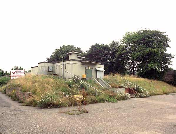
6 Group HQ on the site of RAF Old Catton, opened on 27th September 1961. It consists of a three level bunker with a prefabricated accommodation block alongside. The top level is entered up a flight of steps, the middle level is semi-sunken below a conspicuous mound and the bottom level is completely below ground. The accommodation blocks, now in a very dilapidated state and roofless. An ATC hut on an adjacent plot of land is still in use.
Local property developers Belmont Industries bought the site at auction in 1997 but were unable to find a use for it. In 2001 they received planning permission to build a Pizza Hut but the company pulled out. In 2001 some parts of the mound were excavated down to the roof of the middle floor.
The bunker is of the standard semi-sunken design with a pagoda style entrance blockhouse. Inside the entrance blast door there is a short corridor with a further blast door on the right into a small fan room. This fan is for cooling all the plant located in the room directly below it. Adjacent to this room is the main filter room with banks of filters still in place. On the other side of the corridor is the two room decontamination area, each room still containing sinks and water tanks although the shower has been ripped out. At the end of the corridor are the stairs, alongside there was a winch down to the middle level but this was removed long ago.
At the bottom of the stairs is the sewage ejection room. This was intact but we were allowed to remove two compressors which will be relocated in the preserved Dundee Group HQ at Craigiebarns. From here a dog leg leads into the main north - south spine corridor. The first room on the right is the ventilation and filtration plant room and at the back the standby generator room. The plant room has not been modernised or refitted and still contains all its original plant from 1961 in good condition. This includes the main fan, exhaust fan, two compressors, two pumps, gas fan, two condensers and the control cabinet. Within the room there is a small filter room. The generator is also in good condition with two floor standing control cabinets and only a few thousand hours on the clock.
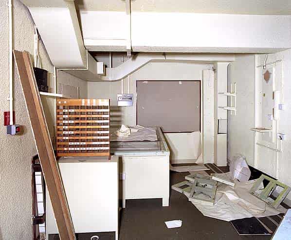
The next room on the right is the canteen and within it the small kitchen. The canteen has been stripped apart from a rack of wooden lockers. The kitchen still retains its preparation surface, water heater and a serving hatch into the canteen. The next room on the right is the BT room which still has a lot of wiring and two wall mounted cabinets and a small section of a distribution frame. Next on the right is a store room and stairs down to the bottom level and then two doors onto the control room gallery.
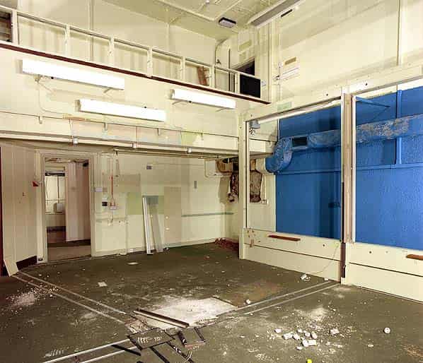
The control room is well preserved with its 8 post display boards. Unfortunately 7 of them have been dismantled and lie in a pile on the floor, the eighth is still in place above the well. At the back of the gallery is the triangulation alcove; this is where all the raw data from the posts was collated and the location, height and size of burst calculated and displayed for the Control Room to use. A Bomb Power Indicator and Fixed Survey Meter would have been located here and although they have been removed their position was evident. Sitting in the alcove is the ‘Triangulation Rack’ consisting of 81 ‘cubby holes’ in rows of 9. Bearing, elevation and spot size was received by landline from each post by the Post Display Plotter. The plotter used this information to complete ‘Form Triangulation’ which was placed in one of the cubby holes, one hole for each post.
In the alcove is a large floor standing light box known as the ‘Triangulation Table’. The top of the table has little holes, each one indicating the position of a post within the Group. There are no names or geographical features on the table. The table is marked with the GEOREF Grid (A worldwide position-reference system that may be applied to any map or chart graduated in latitude and longitude, with Greenwich as the prime meridian, regardless of the projection. It is derived from the World Geographic Reference System.) and a faint OS National Grid. The pin of a protractor slotted into the hole and the information from Form Triangulation was plotted.
On the edge of the balcony a rack of wooden slats is still in place. These were called ‘Nuclear Burst Slats or Totes’. The bomb position, height and yield was marked on these slats with a dry wipe marker. This information was calculated from the data on the Triangulation Table. The information carried on each slat indicated air or ground burst. GEOREF, national grid reference, designation (i.e. NORD or LINB etc.- each bomb was given its own reference in order A, B, C, D, E etc so the first to be worked out in Norwich Group was known as NOR A this applied only to a bomb in that group. Adjoining group Lincoln used LIN etc. If there was a burst on the boundary the triangulation supervisor would phone Lincoln’s Triangulation Supervisor to agree on a designation so as to avoid duplication), bomb power, height and time. This information was then read from the other side of the balcony by the scientific team and ‘told’ to a teleprinter (later VDU) operator with whom they had headset contact and sent off to all Group Controls, County Controls, RGHQ’s etc. The Home Office scientific team were downstairs working on the large illuminated display (Display A) looked up to see the latest information on the slats. This was usually brought to their attention by banging the slats loudly on the top of the balcony before placing in the tote (rack)!
On the lower floor the frames that held the Perspex ‘A’ and ‘B’ displays are still in place although the Perspex screens have gone. Beyond the second entrance to the gallery there were two wooden doors forming an airlock. One has been removed, the other is still in place and marked ‘Emergency Exit’ Beyond this there would have originally been a ladder up to the emergency escape hatch but this has been removed and there are now stairs up to another blast door at the back of the mound.
On the left side of the spine corridor the first room is the ladies toilet with two hand basins, two WC cubicles, a shower and a sanitary towel incinerator. Beyond this is the male toilet with two urinals, two hand basins, 1 WC cubicle and a shower. The next two rooms were the male and female dormitories which have been completely stripped and the final room on this level is the officers room which is also empty.
At the bottom of the stairs the control room ‘well’ is to the left. This has been sub-divided with windows into the smaller communications centre which has acoustic peg-board fitted to all the walls. To the right at the bottom of the stairs are two rooms. One was the radio room, this still contains part of an equipment rack.
The bunker is dry throughout and although it has always been secure there has been some vandalism (possible by site workers) as some of the hand basins have been smashed. Power and water are no longer connected.
Those taking part in the visit were Nick Catford, Dan McKenzie, and Robin Ware. Thanks to Ward and Caroline Westwater of the Civil Defence & Emergency Service Preservation Trust for arranging the visit.
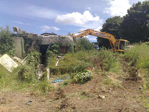
UPDATE 2008: The future of 6 Group HQ has been in the balance for many years but despite a spirited local campaign to restore the bunker as a tourist attraction in 2008, the owner demolished the bunker in early July 2008 to put a halt to the campaign despite the fact that there is currently no planning permission to develop the site.