RAF Fullarton was established as a Ground Control Intercept (GCI) radar station (13G) during WW2. It went through first two stages of development: ‘mobile’, ‘intermediate transportable’ but did not reach ‘final’. Early stations (from 1940) had equipment on wheeled caravans and temporary wooden hutting; these were replaced by intermediate stations which had the aerial arrays mounted above and below a wooden gantry, with operations carried out from wooden huts.
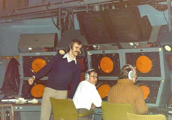
Final stations, built from 1942, had brick operations blocks, known as ‘Happidromes’. These stations had a single rotating aerial array with the transmitter and receiver housed in a well below ground designated an R7. Although the happidrome at Fullarton was started on 10.9.1942 work was halted at the end of December and Fullarton remained as an intermediate GCI station where the Ground Controller working from his PPI (Plan Position Indicator) display screen would be able to talk directly to the pilots of the fighters they were controlling giving them directions to intercept the enemy aircraft that were within range of the aircraft’s own intercept radar. An aerial photograph taken on 1.8.45 shows the happidrome to be incomplete without a roof.
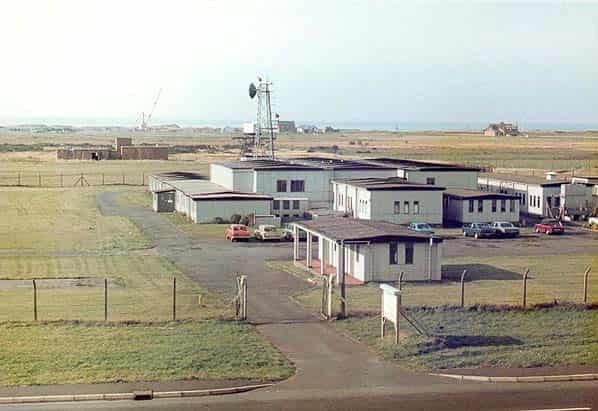
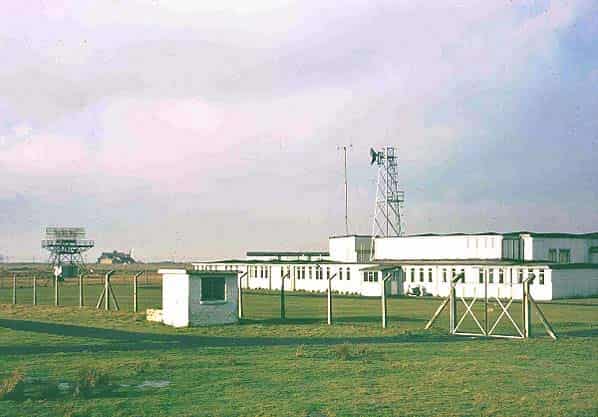
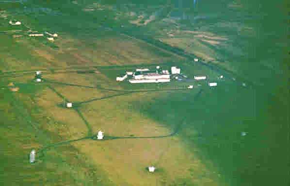
RAF Fullarton closed at the end of the war and was placed on care and maintenance until the early 1950’s when that station was selected to take part in the ROTOR programme. By 4.12.1950 most of the buildings from the old GCI station had been cleared away ready for the new station which was to be known as RAF Gailes. The Happidrome was sold and for some time the building was used as a concrete products factory. As the station was on the west coast underground protected accommodation was not required. Initially an R6 technical block was planned but this was later changed to a less substantial SECO R8 building made of prefabricated asbestos and wood fibre board.
As planned, the station was to be fitted with the following radars one Type 7 Mk. II, one Type 11 mobile Mk. VII, two Type 13 Mk. VI, three Type 13 Mk. VII, one Type 14 Mk.VIII and one Type 14 Mk. IX. It was also intended that a Type 80 should also be fitted at a later date once development of this new radar had been completed. The projected completion date for RAF Gailes was 19.7.1953 with the camp ready for occupation by 1.12.1953. There was to be no purpose built camp or married quarters for Gailes, instead the station would share the Dundonald Army Camp.
With the forthcoming installation of Type 80 radar the two Type 14’s and the Type 7 radars were deleted on 27th February 1952.
On 27.1.53 Fighter Command’s requirement for an American AN/FPS3 long range search radar for Ventnor (Isle of Wight) was switched to Gailes and as completion of the station had been delayed this was fitted in a temporary operations hut Type B. At the same time, the Type 11 mobile was also deleted as this was no longer required. Gailes was promoted to No. 8 on the fitting list with the standby set house due for completion by April 1953 and the station on line by 1954. Gailes was No 1 in order of priority of six stations awaiting production of Stage1A (T80) radar but despite this the Type 80 was deleted from the programme in November 1953 before the station was completed even though its modulator building had already been finished.
Construction and fitting was further delayed and the station was finally handed over to the RAF as a readiness GCI station on 22.2.1956. Its order of priority in the control and tracking list of radar stations was 24 out of 29; a readiness station requires notice before it can be brought fully on line. The technical transfer of Gailes to the RAF marked the completion of the Rotor 1 programme on 22.2.1956. The station was also provided with remotely sited Chain Home Extra Low (CHEL) radar at NS35863353.
The station was short lived however and a hand written amendment to Chapter 3 of ‘Operational Rotor 3’ states that ‘there will be no further requirement for the Rotor 1 GCI station at Gailes when Killard Point (Northern Ireland) becomes operational, i.e. when fitted with AN/FPS3’.
In September 1956, 157 Signals Unit at Gailes was disbanded and the station placed on care and maintenance. The air traffic control functions were transferred to Prestwick. The station was not required for the 1958 plan. In 1962 the CAA (Civil Aviation Authority) moved in to the redundant buildings at Gailes with the installation of the first Scottish area control radar on the Ayrshire coast, this involved an extension to one of the buildings to house the CAA radar. It worked in conjunction with a procedural area control centre at Redbrae House next to Prestwick Airport.
The Type 7 and Type 14 radars from the original 1953 ROTOR installation were in civil use until about 1977 when they were finally decommissioned before they literally fell apart.
The CAA remained at Gailes until 1978 when operations were transferred to the new function at Atlantic House in Prestwick. The Gailes station was decommissioned and dismantled over the following year and the site was transferred to Irvine Development Corporation for housing. Possibly due to the deep sandy soil or simply no interest by builders to build outside of the main developments and town of Irvine, houses were never started and the site lay unused except for a few sheep and a halfhearted attempt at forestry. The site was developed into a golf course in 2004.
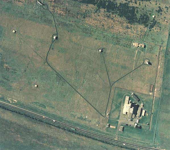
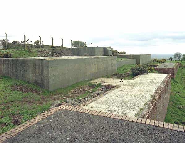
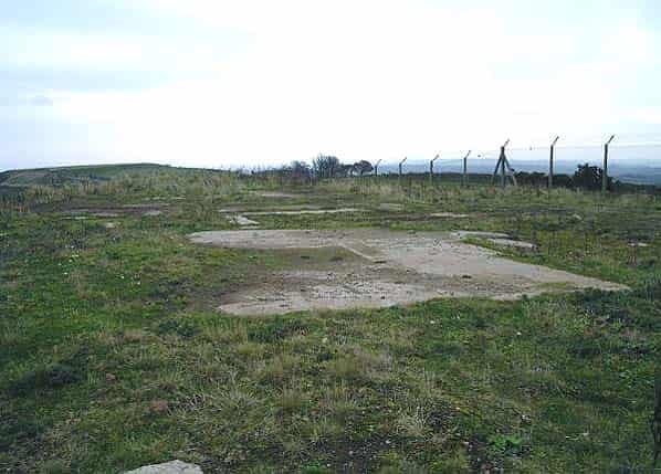
It’s not known when the R8 was demolished; it is shown on the 1974 Ordnance Survey Pathfinder map but by the 2001 Explorer map it had gone. When visited in August 2004 the only evidence was some recognisable rubble on the site of the R8 and some fencing along the northern site boundary.
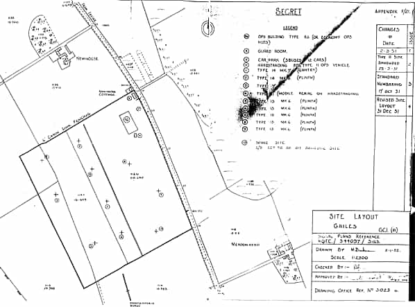
In order to provide communication between the controllers at RAF Gailes and the intercepting aircraft, two VHF/UHF multi-channel radio transmitter and receiver blocks were built at remote sites at Dundonald. Transmitter and receiver blocks come in two sizes designated ‘small’ and ‘large’; those at Gailes, were ‘large’. Each block would have had a 90' wooden aerial tower alongside.
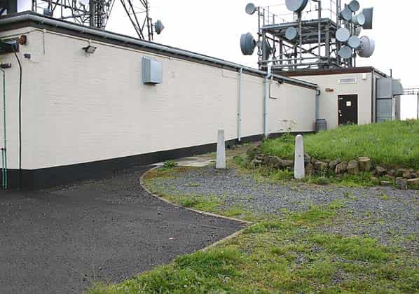
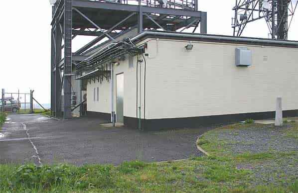
Each site consisted of two buildings, the operations building and a standby set house. As built, the transmitter building comprised the transmitter hall, mechanical and electrical room, store, workshop, staff room and toilet. The building still stands on Wardlaw Hill at NS36053250 although it has been refurbished and extended and now a NATS (National Air Traffic Services) microwave and VHF relay station for the Scottish Area Control Centre at nearby Prestwick.
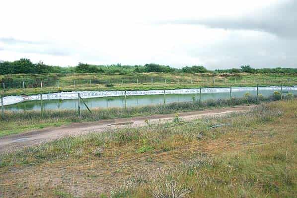
The smaller receiver building at NS35523313 comprised a receiver room, mechanical and electrical room, store, workshop, staff room and toilet. This building has been demolished in recent years. Although some of the fencing and the concrete base for the receiver building and standby set house can still be seen. The CHEL technical buildings have also been demolished during the expansion of Hallyard’s Quarry.
In the early 1960’s Dundonald was selected to participate in the Passive Detection System. Production started in 1962 some time before development of the equipment was complete. The first successful demonstration was given to NATO in May 1964, using the experimental Type 85 radar (Blue Yeoman) at Malvern and the high speed scanning PDS aerial at Bushey Hill. The complete operational installation for ADUK (Air Defence of the United Kingdom) consisted of three base lines.
These were provided by the three Type 85 radar sites, Neatishead, Staxton Wold and Boulmer, at each of which there was also to be a PDS high-speed scanning aerial, and one further site, Dundonald at which there was to be only a PDS high-speed aerial.
The target date for the first trials to start at Neatishead was October 1965. Although that installation proceeded almost to plan, those at Staxton Wold and Boulmer proceeded more quickly and these two stations would, together, provide the first complete base-line equipment; trials there were planned for February 1966. Final-acceptance trials took place at Staxton Wold in May-June 1968 and it was handed over to the RAF in October 1968. Boulmer and Dundonald followed in November 1968 and Neatishead in December 1968 with Dundonald being remotely operated from Boulmer.
It is believed that this was located on Wardlaw Hill, close to the Gailes VHF transmitter block. There are a number of concrete bases within a large compound close to the trig. station. These bases are for the two dishes and buildings of an air defence troposcatter station which opened in 1988 and remained operational for about ten years The station at NS35943274 was known as HTS Wardlaw Hill and was continuously manned by RAF personnel from Prestwick.
Sources:
- Bob Jenner
- Keith Ward
- Ian Brown
- Steve McNamara
- Paul Ravenscroft
- Jim Duff (NATS)
- Various PRO files: Air 2/11178, Air 8/2032 Appendix C, Air 8/1630 Appendix B (1952), Air 20/7324 Appendix D (4.12.1950), Air 2/12116 (27.2.52), Air 20/11320 (27.1.53), Air 20/10699 Appendix J (Nov 1953), Air 20/10699 Chapter 3 Operational Rotor 3, CRPC/G301 Outline plan for operational Rotor 1