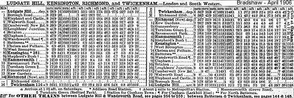
|
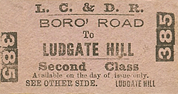
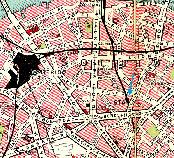
Notes: Borough Road station was opened with the LCDR's City Line on 1 June 1864. Prior to opening no reference to the station was made by Captain Tyler RE in his report of 30 May 1864 for the Board of Trade.
 The line was built as double track but it saw heavy use and it was soon clear that the formation between between Charlotte Street, Blackfriars and Walworth Road would need to be widened to four roads to cope with the demand. Once this had been completed the line was once again inspected by the Board of Trade. In his report of 11 July 1886 Col. Yolland did make some recommendations about Borough Road, stating 'A railing is required on the top of the girder bridge adjacent to the Borough Road Station. The Signal Box should he separated from the platform by a ramp.' The line was built as double track but it saw heavy use and it was soon clear that the formation between between Charlotte Street, Blackfriars and Walworth Road would need to be widened to four roads to cope with the demand. Once this had been completed the line was once again inspected by the Board of Trade. In his report of 11 July 1886 Col. Yolland did make some recommendations about Borough Road, stating 'A railing is required on the top of the girder bridge adjacent to the Borough Road Station. The Signal Box should he separated from the platform by a ramp.'
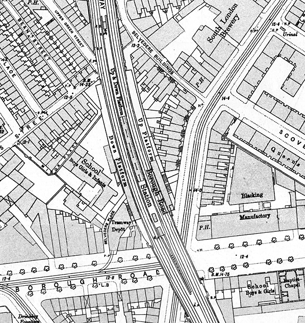
After rebuilding fir the widening the station had two side platforms and a central island The latter was longer than the others and its London end, which stopped a little short of the bridge over Friars Street (now Webber Street), accommodated the signal box. The platforms and buildings, which included flat canopies, were constructed from wood, with those on either side projecting from the viaduct, supported at the rear by a succession of columns. The island platform was also provided with a canopy with a curved cross section and an attractive deep valance. Covered stairways lead to the rear of the platform buildings from the street level booking hall.
 By the first decade of the20th century the station had few passengers due to competition from trams. Those shown on the map below were electrified in 1904, and took most of the traffic from the station; as a result, most trains went through without stopping. A contemporary satirical report by York Hopewell in the February 1901 issue of Railway Magazine painted a bleak picture, "A comparatively little—known railway station in London is that known as 'Borough Road'. Now, there are few folks indeed who have not heard of the 'Borough' and there is a vast number of Londoners who know the famous 'Borough Road' well enough. But if you ask many of them if they know the 'Borough Road Railway Station,' it becomes another story altogether. The suburban resident who travels up to town daily from Peckham district and onwards, is generally too much occupied with his copy of the morning paper to notice the names of stations where his train stops, let alone those where it doesn’t. Ask such a man just to give you the names of the stations (in order) that he passes from Ludgate Hill to Peckham, or vice versa, and you’ll be astonished at his replies. Yet he may have done the journey twice per diem, often for a dozen years! By the first decade of the20th century the station had few passengers due to competition from trams. Those shown on the map below were electrified in 1904, and took most of the traffic from the station; as a result, most trains went through without stopping. A contemporary satirical report by York Hopewell in the February 1901 issue of Railway Magazine painted a bleak picture, "A comparatively little—known railway station in London is that known as 'Borough Road'. Now, there are few folks indeed who have not heard of the 'Borough' and there is a vast number of Londoners who know the famous 'Borough Road' well enough. But if you ask many of them if they know the 'Borough Road Railway Station,' it becomes another story altogether. The suburban resident who travels up to town daily from Peckham district and onwards, is generally too much occupied with his copy of the morning paper to notice the names of stations where his train stops, let alone those where it doesn’t. Ask such a man just to give you the names of the stations (in order) that he passes from Ludgate Hill to Peckham, or vice versa, and you’ll be astonished at his replies. Yet he may have done the journey twice per diem, often for a dozen years!
 So there is little wonder that, if by chance, the passenger does notice the name 'Borough Road Station' as the train runs through it, he is simply content with that notice and troubles no more as to what sort of place this station is. For few trains indeed, stop at this London station, since it is so near the termini of Ludgate Hill and St. Paul’s. There are two sets of lines passing through Borough Road Station - one, the main line of the London Chatham & Dover, and the other what is called the 'Metropolitan Extension' line. On this latter there are a large number of trains daily, though few stop here; but on the London Chatham and Dover line the 'stoppers' are even worse. An official at the station some time ago told the writer that he could recollect more than one instance where there had only been one train stop on that line during the whole twenty-four hours! As a proof of the 'busy state of the Borough Road Station, it may be interesting to learn that the whole staff on regular duty consists of an 'inspector' (who collects tickets, shuts carriage—doors, and does lots of other things), and two lads, who help in shutting doors, carry an occasional bag now and then - when a passenger does, by any mistake, get out at this place — and shout out the name of the station to people in trains, who never under any pretence wish to disembark here. Three officials, two boys, and a man to manage a fairly large London railway station! Is there any other that can beat this record?" So there is little wonder that, if by chance, the passenger does notice the name 'Borough Road Station' as the train runs through it, he is simply content with that notice and troubles no more as to what sort of place this station is. For few trains indeed, stop at this London station, since it is so near the termini of Ludgate Hill and St. Paul’s. There are two sets of lines passing through Borough Road Station - one, the main line of the London Chatham & Dover, and the other what is called the 'Metropolitan Extension' line. On this latter there are a large number of trains daily, though few stop here; but on the London Chatham and Dover line the 'stoppers' are even worse. An official at the station some time ago told the writer that he could recollect more than one instance where there had only been one train stop on that line during the whole twenty-four hours! As a proof of the 'busy state of the Borough Road Station, it may be interesting to learn that the whole staff on regular duty consists of an 'inspector' (who collects tickets, shuts carriage—doors, and does lots of other things), and two lads, who help in shutting doors, carry an occasional bag now and then - when a passenger does, by any mistake, get out at this place — and shout out the name of the station to people in trains, who never under any pretence wish to disembark here. Three officials, two boys, and a man to manage a fairly large London railway station! Is there any other that can beat this record?"
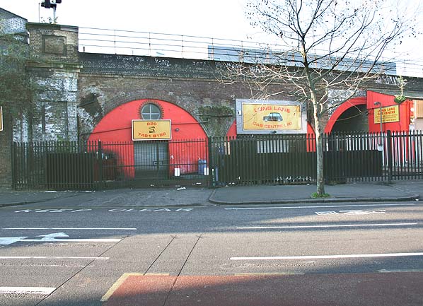
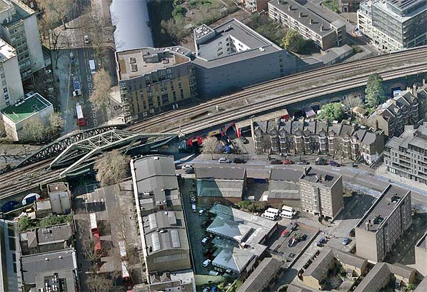
Borough Road didn't survive much longer, closing on 1 April 1907. The timber platforms, steps and track level buildings were demolished. The signal box closed on 21 March 1926. The street level entrance below the arches on the west side of Southwark Bridge Road just north of its junction with Borough Road found later use as a care repair workshop. It is believed some kind of stairway from here to the track level survived until the early 1980s as did two columns that once supported the up platform attached to the side of the viaduct. At track level a widening of the formation, as can be seen in the aerial photo below, indicates the position of the narrow central island platform.
Additional source: London's Disused Stations Volume 3 - The London Chatham & Dover Railway. JE Connor. Connor & Butler 2002.
BRIEF HISTORY OF THE LCDR's
'CITY LINE'
The Metropolitan Extensions Act of 1860 gave the London Chatham
& Dover Railway access to the City, authorizing a 4.5 mile
line from Herne Hill across the river to join the Metropolitan
Railway at Farringdon Street.
 The 'City Line' was far more than the Chatham could cope with
financially, but the possibilities for through traffic were
vast. To the north the G N R and the Midland could be reached
and to the south were the L B S C R and L S W R at Clapham Junction
from where the G W R and L N W R could be reached via the West
London Line. All these companies were approached to partake
financially and all eventually profited from the scheme gaining
the right to work trains to their own goods and coal depots
in South London. The 'City Line' was far more than the Chatham could cope with
financially, but the possibilities for through traffic were
vast. To the north the G N R and the Midland could be reached
and to the south were the L B S C R and L S W R at Clapham Junction
from where the G W R and L N W R could be reached via the West
London Line. All these companies were approached to partake
financially and all eventually profited from the scheme gaining
the right to work trains to their own goods and coal depots
in South London.
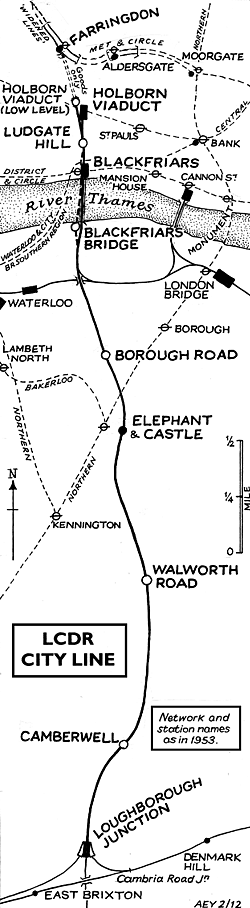
The line from Herne Hill to the Elephant and Castle was opened
on 6 October 1862 and on to Blackfriars Bridge on 1 June 1864.
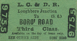
Intermediate stations were initially provided at Camberwell,
Walworth Road and Borough Road and later at Loughborough Junction.
The Thames was eventually bridged and by 21 December 1864 a
temporary station at Ludgate Hill was in use, a permanent station
being opened on 1st June 1865. It had two narrow island platforms
but the station was rebuilt in 1910 with a single broader island
platform.
 On 1st January 1866, L C D R passenger trains began running
into the Metropolitan's Farringdon Street station and the connection
was soon carrying a wide variety of passenger and freight services.
Then, by an Act of 13 July 1871, the Chatham became committed
to yet another project. A nominally independent Holborn Viaduct
Station Company (for the bankrupt Chatham was not allowed to
raise capital) was authorized to build a 292 yard branch from
the Ludgate - Farringdon line to a new terminus, complete with
hotel, fronting on the new thoroughfare of Holborn Viaduct.
It was opened on 2nd March 1874. On 1st January 1866, L C D R passenger trains began running
into the Metropolitan's Farringdon Street station and the connection
was soon carrying a wide variety of passenger and freight services.
Then, by an Act of 13 July 1871, the Chatham became committed
to yet another project. A nominally independent Holborn Viaduct
Station Company (for the bankrupt Chatham was not allowed to
raise capital) was authorized to build a 292 yard branch from
the Ludgate - Farringdon line to a new terminus, complete with
hotel, fronting on the new thoroughfare of Holborn Viaduct.
It was opened on 2nd March 1874.
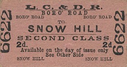
On 1st August 1874 a low-level station, Snow Hill ('Holborn
Viaduct Low Level' from 1912), was opened at the foot of the
1 in 39 incline.
Finally, on 10th May 1886 a parallel bridge across the Thames
was opened with, at the northern end, yet another new station,
St. Paul's, the original Blackfriars Bridge being closed. St.
Paul's was renamed Blackfriars on 1st February 1937. The existing
layout was completed when the South Eastern Railway opened the
Union Street spur on 1st June 1878 creating a through route
into Charing Cross.
The difficulties of inter-terminal transfer through the congested
streets of mid-Victorian London assured considerable transfer
traffic. All L C D R mainline trains, including continental
ones, carried a City portion attached or detached at Herne Hill.
Eventually however the development of the underground network
led to the withdrawal of the through services and the demise
in the importance of Holborn and Blackfriars with a dramatic
reduction in off peak services. Holborn retained very heavy
parcels traffic, including continental and three of its six
platforms, too short for electric trains were utilised.
 The first casualty on the line was Borough Road which closed
on 1st April 1907 due to competition from the Northern Line.
As an economy measure during WW1 through services from south
of the Thames to Moorgate via the Smithfield Curve (opened 1.9.1871)
were withdrawn on 1st April 1916 with Camberwell and Walworth
Road stations closing two days later. Holborn Viaduct Low Level
closed on 1st June 1916 and with it through passenger traffic
on the City Line ceased. The first casualty on the line was Borough Road which closed
on 1st April 1907 due to competition from the Northern Line.
As an economy measure during WW1 through services from south
of the Thames to Moorgate via the Smithfield Curve (opened 1.9.1871)
were withdrawn on 1st April 1916 with Camberwell and Walworth
Road stations closing two days later. Holborn Viaduct Low Level
closed on 1st June 1916 and with it through passenger traffic
on the City Line ceased.
Less than 700 yards separated Holborn Viaduct from Blackfriars.
Ludgate Hill thus became increasingly redundant, especially
after the through trains stopped. The intensive Ludgate Hill
- Victoria services were withdrawn during the First World War.
The Wimbledon trains were the last to call and with their electrification
it was closed on 3 March 1929.
In 1902, 19.2 million passengers used Holborn, Ludgate and
St. Paul's. Use declined with the loss of the cross London traffic
until electrification. The growth of L.C.C. estates in S E London
and Kent increased traffic but this was not maintained and in
1960 they were back to the 1902 level with 88% of the traffic
arriving or departing during the rush hour. The 'City Line'
was still a vital north-south freight link with some 90 trains
a day in 1962, but all regular freight and parcels services
were withdrawn in 1969. Although disused for many years the
Snow Hill tunnel was finally abandoned in 1971 and the track
was lifted.
 The Snow Hill tunnel was reopened in 1988 as part of the new
Thameslink
network which came into service in May 1990, initially as part
of British Rail but private since March 1997. To coincide with
the opening of Thameslink,
Holborn Viaduct Station was closed on 22nd January 1990. The
line into Holborn Viaduct over Ludgate Hill was removed and
a new line built that drops down steeply from Blackfriars station
into a new station called City Thameslink (opened 29.5.1990)
beneath the former Holborn Viaduct Station. The station was
originally called St. Paul's Thameslink but was renamed in 1991
to avoid confusion from St. Paul's station on the Central line. The Snow Hill tunnel was reopened in 1988 as part of the new
Thameslink
network which came into service in May 1990, initially as part
of British Rail but private since March 1997. To coincide with
the opening of Thameslink,
Holborn Viaduct Station was closed on 22nd January 1990. The
line into Holborn Viaduct over Ludgate Hill was removed and
a new line built that drops down steeply from Blackfriars station
into a new station called City Thameslink (opened 29.5.1990)
beneath the former Holborn Viaduct Station. The station was
originally called St. Paul's Thameslink but was renamed in 1991
to avoid confusion from St. Paul's station on the Central line.
The northern part of the Thameslink
network replaced the 'Bedpan' service from Bedford to St. Pancras
and uses the existing Midland Main Line. In the south there
are two branches. The main route runs through London Bridge
to East Croydon and Brighton while the second branch initially
ran into Guildford via West Croydon but has now been rerouted
through Mitcham to terminate at Sutton.
Thameslink
has become a significant commuter route serving the airports
at Gatwick and Luton and carries around 40 million passenger
journeys on the system annually.
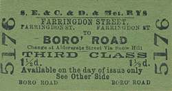
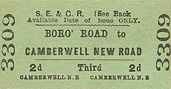
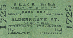
Tickets from Jim Connor except 385 & 3309 Michael Stewart. Route map by Alan Young. Bradshaw from Chris Hind.
Sources: A
regional history of the railways of Great Britain - Volume
3 Greater London by H P White. David & Charles 1963 &
1971 ISBN 0 7153 5337 3
Other web sites: Abandoned
Tube Stations - includes a cab ride from Farringdon - Blackfriars
To see the other stations on
the LCDR's 'City Line' click on the station name: Loughborough
Junction, Camberwell,
Walworth Road,
Blackfriars Bridge,
Blackfriars, Ludgate
Hill, Holborn
Viaduct,
Snow Hill/Holborn Viaduct
Low Level & Farringdon
|

road_old1.jpg)
road_old2.jpg)
road_old3.jpg)
road_aerial.jpg)
 Borough
Road station entrance on the east side of the viaduct in December 2005; now in use as a car repair workshop.
Borough
Road station entrance on the east side of the viaduct in December 2005; now in use as a car repair workshop.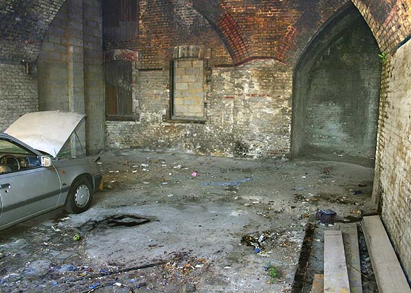
 Home Page
 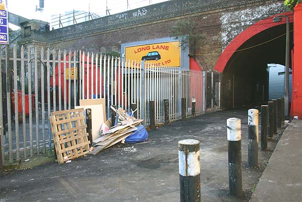 Borough
Road station entrance in December 2005.
Borough
Road station entrance in December 2005.